Relic point Vietnam
Việt Nam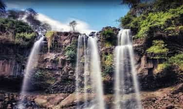
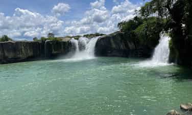
Drai Dlong Waterfall
Drai Dlong waterfall is 35 km from the center of Buon Ma Thuot city, in Quang Hiep and Ea M’Drŏh communes, Cu M’gar district, Dak Lak province. Drai in Ede means waterfall; Dlong means high, so Drai Dlong means high waterfall. In addition, this landscape is also known as a three -storey waterfall. Located in the southwest of Quang Hiep commune, made up of two hills covered with an average height of 500m above sea level, the flow of Drai Dlong waterfall originates from the flow of two Ea’Drǒh streams (big streams) and Ea M’Drǎh stream (small stream), to the section near the waterfall about 01 km, blend into each other, meet large rocks, divide and divide the height of 30m to block the height of three branches. The white silk strip from above poured down. From the bottom to look up, the great waterfall, sparkling with silver, surrounded by good green forests with rising trees to adapt to the vertical cliff terrain, there are many rare timber trees such as stars, incense, chit, purple mausoleum, especially cactus growing on rocks. About 01 km from Drai Dlong Waterfall is M’Drŏh (Buon Chay), this is the trading of Ede people. During the years of resistance against the US, M’Drŏh traders, along with forest merchants, traders, Ea Win merchants transported food to the resistance from the A10-B3 station via Ea H’Leo, Krong Bong and to Phu Yen, Khanh Hoa. Buon M’Drǒh is a base of H5, the people in the village have persisted in fighting, organizing patrols to guard, bringing, raising revolutionary officials, bustling, trapping and manufacturing rudimentary weapons to protect the village. During the fierce war, the enemy organized a sweeping, persecuted, brutally beaten, but the people of M’Drǒh from the old, young, boys and girls would rather be beaten, hungry rice, but not to cooperate with the enemy, a heart of the Party to the end. When the enemy discovered that this was a facility that hid revolutionary officials, even M’Drǒh was burned and no longer had any home, so the merchant was also known as the fire. On December 15, 2004, the Ministry of Culture, Sports and Tourism ranked Drai Dlong waterfall as a national landscape monument. Source of electronic portal in Dak Lak province.
Dak Lak
3436 view
Rating : National relics.
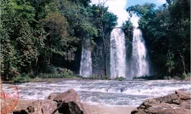
Drai Yong Waterfall
Drai Yong Waterfall is located in Ea M’nang commune, Cu Mgar district and Cuo Knia commune, Buon Don district, 22 km from the center of Buon Ma Thuot city to the Northwest. Drai Yong Waterfall was ranked National Monuments in Decision No. 823/Decision -The Culture and Sports Culture on March 9, 2017 of the Ministry of Culture, Sports and Tourism. The total area of the relics protection area: 83.62 ha (Area I: 5.83 ha; Area II: 77.80 ha). In Ede, Drai Yong Waterfall, meaning "Thunderstorms" or "strong waterfall". This is a beautiful waterfall located in the middle of the Ea Tul stream - a stream originating from Kǒ Kpo stream, Krong Buk district. Ea Tul stream has the flow from east to west, finally flowing into the Serepok River. On his flow, this stream creates three beautiful waterfalls: Drai Kroa, Drai Yong and Drai MPI. In this waterfall system, Drai Yong is the most poetic and majestic waterfall. The upstream of Drai Yong is a nearly 100m wide stream, 48 northern banks are bamboo bushes, half -growing pineapple and regenerated forests that are planted by local authorities to restore landscape and create an environment for the monument. The southern banks are smooth green lawns and lush corn fields. When there was only about 10m from the waterfall, the water from the upstream suddenly swirled back, suddenly broken down a deep valley to create the Drai Yong waterfall. The place where the waterfall has a width of about 80m and a height of about 12m, the water is swirling to create sounds that echo the whole area. Steam, dust from the white, blind flying waterfall like the fog floating in the air, when the sun shines through this steam becomes a dazzling rainbow band in the morning sun. The landscape of Drai Yong Waterfall is a component of the relics of Cu Mgar district and Buon Don district. With a poetic natural landscape, fresh and airy air, Drai Yong Waterfall is an ideal tourist destination, which has a great attraction for enthusiasts of outdoor picnics, wanting to find nature to dispel stress, fatigue after heavy labor days in urban areas that are stable, bustling and dusty. In addition, the ecosystem around the waterfall also preserves many pristine features, close to the center of Buon Ma Thuot city, the traffic is relatively convenient for tourists inside and outside the province as well as international visitors to visit, experience and explore at this scenic name. Source of electronic portal of Cu Mgar district, Dak Lak province
Dak Lak
3651 view
Rating : National relics.
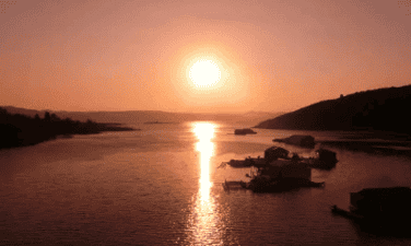
The relics of Ho Lak landscapes
Ho Lak in the language of the Mnong people, the word "Lak" means "water". Ho Lak also known as Lac Thien Ho, located in Lien Son town, Lak district, 56km south of Buon Ma Thuot center on Highway 27 to Da Lat. Lak Lak has an area of more than 500 hectares, this is one of the largest natural lakes in Vietnam, the southwest of the lake with the Krong Ana River (Wife River) is one of the big rivers of the Serepok stream, the west of Lak Lake is the majestic ču Yang Sin sequence like the chest of the strong guy shielding the lake of the four -season lake of the mountain. From the top of Lac Thien Pass of Yang Ro Buon in Lak Yang Tao commune, we will see the lake appears with a splendid beauty - clouds, water, hills, mountains, fields mixed together as a picture of water. Ho Lak is also associated with the legend of the fire and water of Mnong people. The story is that: The day has been, in the past, it was a long time ago, not knowing because of the reason for the god and the fire god suddenly contradicted each other. After a battle, the god lost the battle to enter a rock. Since then, drought began to occur, in a few years, there was no rain, trees and animals died. The villagers face up to the sky, the sound of the resentment. One day, there was a poor boy leaving, determined to find water for the village. He kept going, going forever, once tired, the boy sitting on a rock with an eel lying curled up. He made the eel brought back in a pot, the next morning he suddenly saw a drop of water from the eel's mouth released, stagnant at the bottom of the pot. He felt that: The water god here!. He dropped the eel and kept following the eel mark and went, went forever, until the eel disappeared, it was just a vast lake that appeared before his eyes. The boy rubbed his eyes once, twice, then once again dared to believe that he was not dreaming. Lak Lak has from there. Today, Ho Lak is an attractive tourist destination, coming here visitors will be riding elephants, sailing, learning about the traditional customs and traditions of the Mnong ethnic community at the Mlieng Trading - one of the preserved ancient traders of the province. Besides, Lak Lake is also a large fish bowl of the province, a source of abundant fisheries to serve the lives of the people. In particular, on the top of the hill next to Lak Lake was built by King Bao Dai to rest and watch the landscape. Palace is currently restored and exploited by Dak Lak Tourism Company to serve tourists. On 11/5/1993, Ho Lak was recognized as a national landscape monument. Source of electronic portal in Dak Lak province
Dak Lak
3719 view
Rating : National relics.
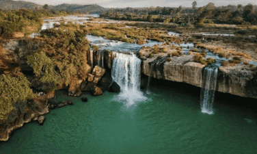
Dray Thuong Waterfall (Gia Long Waterfall)
Dray Thuong Waterfall is located on the Ea Krong River, next to Kuop Buon in Ea Na commune, Krong Ana district, 18km south of Buon Ma Thuot city center. From a distance, Dray Thuong Waterfall stands out a white color on the silver water of the Ea Krong River. The two sides of the river are a vast green of the mountains. Right at the waterfall area, a very majestic image, strong impression that is the image of the Ea Krong river, with the water floating on the upstream, suddenly folded by a stone shelf across the river, about 70m wide. The rushing water in the abyss is about 08m high, echoing a corner of the forest. In the rainy season, the water is filled with the river, we only see a giant, intense waterfall. However, in the dry season, the water flow is completely, forming 09 different large and small waterfalls. Of the 09 waterfalls, there are 05 waterfalls located in the middle of the river from 05 to 10m apart, there is a rumbling water, but there is a gently murmuring water. Dray Thuong Waterfall has since become the love and attachment of the indigenous people here. Expressed through the ancient ancient story of the Ede people full of poetic, about the legend of this Thuong Sung Waterfall. The story says: In ancient times, in an Ede village, there was a very beautiful girl named H’mi, she loved a tall, healthy and gentle boy. Every day, the couple often invite each other to work. One day, after finishing the field, the two invited each other to rest on a rock under the ancient tree. When they were sweating and sweating, they saw a monster, their heads were as big as the mountain, their eyes were like a copper pot, a long beard with their arms, her hair was as sharp as the name, the whole body covered with a white scales, sparkling like silver. The monster flew up to the sky and suddenly fell to the ground like crows grabbing the bait, his legs kicked hard to make a large land sinking and there a giant water column sprayed violently, dragging H’mi was terrified, and her lover was swept away. The boy like a tiger trying to pull his lover but despair, watching his lover disappear into the fog, and sparkling white scales. Since then, the boy turned into a large tree trunk, the root was deep into the rocky rapids, the body of a suffering person who was struggling. And the huge water column turned into Dray Thuong waterfall today. And, at the other end, H’mi was still loyal to crying and crying day and night to reclaim her lover. In addition, Dray Thuong Waterfall is also associated with the following historical event: In the 1930s - 1933, the French colonialists mobilized the people and political prisoners at Buon Ma Thuot's exile house very hard and hard under their torture, torture to build an arc cross through the waterfall along with the hanging bridge across the Ea Krong River. Today, we still see the two sides have two bridges that the French colonialists have built, this is the most convincing history of the cruelty of the French colonialists at that time, there were countless people and political prisoners abandoned the bodies in the forest and abyss. And here, it is also a challenging place, practicing the gods and the will of revolutionary struggle of patriotic communists. On January 4, 1999, the Ministry of Culture and Sports issued Decision No. 01/1999/Decision -The Culture and Sports Culture recognized Dray Sap Thuong Waterfall as a national landscape monument. The management area of the waterfall is 277.5 ha. Source of electronic portal in Dak Lak province
Dak Lak
3739 view
Rating : National relics.
Thuy Tien Waterfall
Located in Giang Tien village, Ea Puč commune, Krong Nang district, about 56 km from the center of Buon Ma Thuot city. Originating from the streams in the deep forest with 4 main waterfalls, each waterfall has its own beauty. Thuy Tien is like a fairy hidden by the mountain forest with the peaceful waterfalls winding among the thousands. Coming to Thuy Tien waterfall, we will be released in the sound of the stream, watching the fanciful picture of nature on both sides of the waterfall, with the cliffs stood up to the middle of the sky, and countless flowers, butterflies, birds, animals. Not only known as a charming painting, but the waterfall is also associated with the ancient folk story of the Ede people. The story is that: In the old days, in an Ede village, there was a boy named Dam Ji, an extraordinary appearance, his limbs solid like stone. Ji is good at hunting, every sword of him is a terrifying animal, but his personality is very impatient and aggressive, if anyone does not mean his intentions, he immediately punish him, so even though he is very talented, he is not admired by everyone, whereas his younger brother is gentle and kind, so he is loved and appreciated by his people. One day, the two brothers went to the forest to hunt for animals, had not hunted any animals but the mouth was thirsty, there was no drop in the forest to drink. While despairing because of thirst, holding the sword in his hand, the hot ji swung on the ground, the sword had just stabbed to the ground and suddenly shook the earth and a stream appeared in front of him, he shouted happily because there was a country to save thirst. He reached out and swung another seven sword to the ground, then at the distance not far from the stream, the wandering, very shaking, the animal panic, he came to see the appearance in front of a stream. Since then, in the forest that the boy often comes to hunting with two streams and streams in the west, everyone named Ea Dah and the east stream are named Ea Puč. But these two streams have two different personalities just like the two brothers Dam Ji. Ea Dah stream in the west has the same personality as the British, very brave and intense. Referring to the name of this stream, people in the area are terrified, if they come here to catch fish, find drinking water to be very wary of air, which will be swept away by the stream, children in the area down to the shower are often lost by the stream. Those who come here to catch fish and praise this stream many new fish to catch fish, if they say this stream has little fish or no fish, the stream will not give the fish, can catch the whole day they will not get any fish. When the angry stream will rise, it will cause floods to get drifted. In contrast, the Ea Puč stream in the east is very peaceful and does not harm people, whoever comes here fishing, catching fish leaves with shrimp and fish full of baskets, so people call the Ea Puč stream as the Hien stream. The stream is like a gentle and kind younger brother who often helps others, unlike the ferocious Ea Dah stream. Besides, Thuy Tien Waterfall is also associated with the beautiful love story between Uncle Ho's army and a beautiful Ede ethnic girl, both bravely fought against the enemy to the last breath to protect the village, protect the revolutionary zone, contributing to the victory of the resistance war against the US to save the country of our people. On March 3, 2009, the Ministry of Culture, Sports and Tourism issued a decision to rank Thuy Tien waterfall as a national landscape. Source of the provincial web portal
Dak Lak
3425 view
Rating : National relics.
Drai Kpôr waterfall
Drai Kpo Waterfall of Buon Trung (often called Buon M’Toi) commune ču Bong, Ea Kar district, about 100km southeast of Buon Ma Thuot city center. In Ede language: Drai means waterfall, Kpro means souls, spirituality, Drai Kpo water, which means "Soul Waterfall", "Spirit Waterfall". The waterfall has long been attached to the lives of the Ede people in the ču Yang in respect for respect, the place of Yang (the god) reigns, for the cool water, for the green forest and bringing life to the villagers. Dray Kpo Waterfall is originated from the Cu Yang (Mountain) range of 769m high, the Dray Kpôr line is the conformity between Ea Kp Dam and Ea Kpir streams from the č kdroah sequence with an altitude of about 700 m, stretching over 100 m wide, reaching about 50 m, from here the water circuit weaving through the stone slot and then the height of the small circuit is down to a small circuit down to a small valley. Broken to create waterfalls up to 30 m high then joined in the Krong Pac river. The waterfall is the continuation of 4 waterfalls, each with its own appearance. Surrounded by primeval forests with many rich flora and fauna. The 500m from the Buon Buon Base is from 1960 to 1975, which marks the revolutionary miracles during the anti -American resistance war. The story says: In the 1960s of the last century, the US - Diem advocated to further implement the war strategies for South Vietnam. Therefore, when the Act 10-59 is enacted. The strategic hamlet conducted throughout the territory, since this side of the 17th parallel. The Central Highlands is not out of that campaign. And Buon Trung is one of the places where the "tactical" intention of Mi Dan used the upper people as the core force (Furo force) to eliminate the communists lying thoroughly used. The revolutionary Base of Dray Kpor was born in the middle of the fire of war. At the same time, a Liberation Army unit was also born (taking the name H1) and stationed right at the foot of Dray Kpôr waterfall. When discovering this base, the United States - Wei repeatedly conducted white terrorists, Buon Trung continuously burden the bombs from the sky. In addition to the poetic, majestic natural scenery, attached to the resistance monuments and close to the village, Drai Kpôr waterfall also provides water to serve irrigation for Buon Trung fields. On December 15, 2004, the Ministry of Culture and Information (now the Ministry of Culture, Sports and Tourism) issued Decision No. 105/2004/Decision -The Culture and Sports Culture Ranking of Drai Kpôr waterfall as a national landscape monument. Source of electronic portal in Dak Lak province.
Dak Lak
3418 view
Rating : National relics.
The resistance base of Dak Lak province (1965 - 1975)
The resistance base of Dak Lak province (1965 - 1975) is a place to mark important historical events in the tradition of national struggle and defense of the people of the ethnic groups of Dak Lak province. This place is not only a communication line, transition from the North to the rear in the Central region to the southern provinces but also the place where Dak Lak Provincial Party Committee and other units in the province chose as a basis, living and revolutionary activities. In particular, the base area is also the place where 3 times the Congress of Dak Lak Provincial Party Committee: The third time (1966), the fourth time (June 1969), the 5th time (November 1971); A corridor to transport officials to strengthen the Central Highlands battlefield in the years 1968 -1973. On December 29, 2023, the Ministry of Culture, Sports and Tourism issued Decision No. 4241/Decision -The Culture and Tourism Culture and Tourism on the ranking of the National Monuments for historical monuments of the relics added to the resistance base of Dak Lak Province (1965-1975), Hoa Le, Hoa Phong, Cu Pui, Yang Mao and Cu Don, including 39 locations. According to the leader of the Department of Culture, Sports and Tourism, the historical sites of the relics added to the resistance base of Dak Lak province (1965-1975), Hoa Le, Hoa Phong, Cu Pui, Yang Mao and Dam Dam are one of 43 relics rated historical, cultural and famous landscapes of the province, valuable and great meaning in history, cultural, historical, scientific and historical; expressing gratitude to the generations of his father sacrificed for the cause of national liberation and national defense; Contributing to educating revolutionary traditions, patriotism and national pride of the people, especially for the younger generation. Source of electronic portal in Dak Lak province
Dak Lak
3682 view
Rating : National relics.
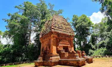
Yang Prong Tower
Cham Yang Prong Tower of Ea Rok commune, Ea Sup district, about 100km west of Buon Ma Thuot city, also known as Green Forest Cham Tower. This is one of the only indigo towers in the Central Highlands built in the late 13th century to worship Siva god in the form of Mukhalinga (great god), praying for the flourishing of the race and happy happiness. Yang Prong Tower, also known as the Green Forest Cham Tower, is a Cham tower located in Village 5 Ea Rok commune, Ea Sup district, Dak Lak province. Legend has it that the tower is the tomb of the head of the old Cham village. In 1906, it was found on the stone frame of the tower of the ancient steles of the Cham king in the late 13th century. The material vestiges around Yang Prong seem to prove this is a old manager of the Cham people in the Central Highlands. The tower is quite intact, higher than 10m, built of hard bricks with many different sizes. The tower has a square jar, the eastern lobby of 1.60m wide. The structure of the square tower, the upper point is like onions, different from the usual Cham architecture. In 1990, many domestic and foreign scientists came to and there were a number of tower research. The scientists all asserted: Yang Prong was built in the 13th century, proving about 700 years ago, the Central Highlands not only had indigenous people but also other ethnic groups. Yang Prong is a monument of great significance for ethnologists, history, architecture ... The tower was built at the end of the 13th century under the reign of Sinhavarman III (Che Man), worshiping Shiva in the form of Mukhalinga, praying for the development of the race, and happy happiness. The Tower of Prong was discovered in the 1904-1911 years by a French ethnicist named Henri Maitre. The scientist described this project in Les Jungles Moi (all forest) published in Paris in 1912. Yang Prong Tower is a red brick architectural block on a blue stone high floor. The tower has a height of 9m, the square bottom is 5m long, each outside is 3 fake doors, a single door opens towards the East direction, where the reign of the gods. Above expanded and soaring pen pyramid, different from the architecture of other Cham towers in the Central. During the war, the tower was searched by gold and mines, so it was much damaged. The tower is also not built on high hills, low mountains without trees like other Cham towers but lying under the ancient canopy of the Ea Sup forest and the peaceful Ea H'leo River. Yang Prong means a great worship tower, a god who specializes in managing crops according to the concept of the ancient Cham people. This is an unfinished project, because when building a tower, Cham people never build one but often a population. Currently, the tower has been recognized as a cultural heritage that needs to be preserved. Despite being embellished, the tower generally retains its ancient and solemn features. Around the tower is surrounded by many years old, quite dense, this is also a testament to the protection efforts of the local government. Not only is a unique artistic architecture, Yang Prong tower has a mysterious ancient Cham nuance and culture, steady ancient existence and sustainability at the same time. On August 3, 1991, the tower was recognized as a national architectural and cultural relic. Source of electronic portal in Dak Lak province
Dak Lak
3683 view
Rating : National relics.
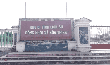
The venue for the co -prosperity
Dong Khoi historical relic area of Hoa Thinh commune is the place to display historical images of Dong Khoi day of the people of Hoa Thinh commune. This is also a place to educate the revolutionary tradition of the commune for young people today and tomorrow, and to serve visitors to learn the meaning of the historical meaning of the Hoa Thinh commune day. This is a national historical monument area by the Ministry of Culture and Information with Decision No. 2005/Decision -Culture and Information on November 16, 2005, ranking the National Monument "The venue for the co -prosperity". Facing the requirements of the new revolutionary struggle, in January 1959, the Party Central Committee issued Resolution No. 15 to determine the basic tasks of the Southern Revolution as "liberating the South from the yoke of the empire and feudalism, the implementation of independence, democracy and plowing farmers, completing the people's democratic revolution in the South", "the basic development path of the Southern revolution is the authorities." Under the light of Resolution 15 of the Party Central Committee, the revolutionary movement in Phu Yen province moved to a new development stage. In September 1960, the first Congress of Phu Yen Provincial Party Committee was held at the Lo Lo base (Dong Xuan mountainous district) to set out the policy and measures to promote the Dong Khoi movement in the plain, recruiting young people to build armed forces, build base areas and mass facilities ... Mr. Duong Du, a historic witness, is one of the revolutionary officials who have emoted the Dong Khoi, the system of the Dong Khoi, the system of Dong Khoi Khoi. After studying, thoroughly grasping the Resolution of the 15th Central Party Conference and preparing forces, at 19:00 on December 22, 1960, the force participating in Dong Khoi started marching from slope to look through the villages and hamlets and then divided into three wings to the headquarters of Hoa Thinh commune, shooting on the enemy's defender platoon. Due to being mobilized before, when listening to gunfire, thousands of people from the directions poured out the road, carrying sticks, spears and armed forces of the district both attacked and rebelled to arrest the Wei Wei, and then focused on the headquarters of Hoa Thinh commune to attend the rally. The force participating in Dong Khoi arrested the vice-deputy representative to hand over the seal, papers, documents ... About 1 am on December 23, 1960, the rally began. The people chanted the slogans: "The American imperial island and the puppets", "The South Vietnam Revolution is definitely successful". At 3 o'clock the same day, the rally ended. Hoa Thinh became the first commune of Zone 5 Delta owned by the revolutionary government. From Dong Khoi Hoa Thinh, the revolutionary force continued to destroy evil and alkaline in the communes of Hoa Dong, Hoa Tan, Hoa My and Hoa Hiep. The liberation area of Phu Yen province expanded with more than 20,000 people, the movement of raising troops, contributing to the revolution to develop more than ever. Also from Dong Khoi Hoa Thinh, thousands of young people of Phu Yen volunteered to join the Liberation Army, escaped into the base, traveling throughout the battlefields of Khanh Hoa and Dak Lak on duty against the US, Wei and Save the country. Source of the website of Hoa Thinh commune, Tay Hoa district, Phu Yen province.
Dak Lak
4015 view
Rating : National relics.
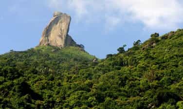
The monument of rocky mountain
Da Bia Mountain is located on Deo Ca mountain range, south of Dong Hoa district. 706m high mountain, east with Ba Ba Hon close to the sea, the foot of the western mountain is National Highway 1A, north with Dong Son mountain, the foot of the southern mountain borders Vung Ro. Stone ridge is very steep with many rocky rocks, overgrown trees, roads to the top are quite hard. On it a tall block of stone is called beer stone. Depending on the perspective, you can see stone beer with different physique. At the top of the mountain, there is a high slope, seeing beer stone like a lion lying down the ribs. At the Hao Son junction - Han Dam looked up, stone beer was like Nhan tower. From Bai Xep - Bai Bang (Hoa Tam commune) looks at, stone stone is like a sitting. At Hoa Tam Truong, looking at stone like a standing Buddha, it can also be said that the monk is down the mountain. At the foot of the mountain, there is Tien beach. In Phu Bien Tap Luc, Le Qui Don wrote: “Da Bia Mountain in Phu Yen is the precursor of the boundaries with Chiem Thanh, the mountain is very far away, the watershed of the coast. This mountain is higher than another mountain. When Holy Tong beat Chiem Thanh to take this land into Quang Nam, set up the old Chiem Thanh lineage, Phong for the land to return to the west, sculpted the peak of the mountain to set up the boundary, his back turned to the north, facing towards, facing towards, facing towards, facing toward Nam, for a long time, the word has been worn out ”. The book of Dai Nam unanimously wrote: “Considering the book of Luc Trinh Chi Chi of Tran Cong Hien, the paragraph is that: This mountain has a limb to the sea, dividing two streams of water, plants and plants, there is a large stone spinning. East head as shown. When King Le Thanh Tong went to fight Chiem Thanh through that mountain, sadly lamented: "Since the time of the early sky, the boundary was divided, because of the inverse of heaven, it had to suffer from heaven." The king made the word touch on the rock. Did King Le Thanh Tong are engraved on the rocky mountain? People still consider it a legend, marking the historical turning point of the land of Phu Yen. Because in Dai Viet historian, there was a journal of the King's Nam Chinh record as follows: "On the first day of March of the New Year of the Rabbit, the 2nd Rabbit, the 2nd day, went down to the army." In 1937, there was a survey of the stele mountain of Tri Tuy Hoa government at that time Nguyen Van Tho. In recent years, there are surveys of young people and students of Phu Yen, they have not found any traces. Rock Mountain (also known as Thach Bi Son) is 706m high, majestic in the north of Ca Deo Rang. On the top of the mountain is a giant 76m high rock block, with strange shapes, early in the morning or in the afternoon, there is often white clouds covered around, when hidden when appearing. Bia Da mountain was recognized as a national landscape monument in 2008. Source of the portal of Phu Yen province.
Dak Lak
4116 view
Rating : National relics.