


List of relic sites (39)
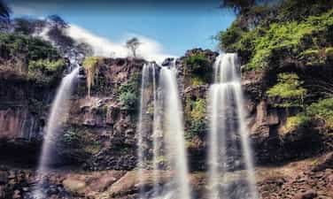
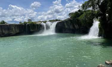
Drai Dlong Waterfall
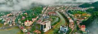
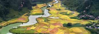
Drai Dlong waterfall is 35 km from the center of Buon Ma Thuot city, in Quang Hiep and Ea M’Drŏh communes, Cu M’gar district, Dak Lak province. Drai in Ede means waterfall; Dlong means high, so Drai Dlong means high waterfall. In addition, this landscape is also known as a three -storey waterfall. Located in the southwest of Quang Hiep commune, made up of two hills covered with an average height of 500m above sea level, the flow of Drai Dlong waterfall originates from the flow of two Ea’Drǒh streams (big streams) and Ea M’Drǎh stream (small stream), to the section near the waterfall about 01 km, blend into each other, meet large rocks, divide and divide the height of 30m to block the height of three branches. The white silk strip from above poured down. From the bottom to look up, the great waterfall, sparkling with silver, surrounded by good green forests with rising trees to adapt to the vertical cliff terrain, there are many rare timber trees such as stars, incense, chit, purple mausoleum, especially cactus growing on rocks. About 01 km from Drai Dlong Waterfall is M’Drŏh (Buon Chay), this is the trading of Ede people. During the years of resistance against the US, M’Drŏh traders, along with forest merchants, traders, Ea Win merchants transported food to the resistance from the A10-B3 station via Ea H’Leo, Krong Bong and to Phu Yen, Khanh Hoa. Buon M’Drǒh is a base of H5, the people in the village have persisted in fighting, organizing patrols to guard, bringing, raising revolutionary officials, bustling, trapping and manufacturing rudimentary weapons to protect the village. During the fierce war, the enemy organized a sweeping, persecuted, brutally beaten, but the people of M’Drǒh from the old, young, boys and girls would rather be beaten, hungry rice, but not to cooperate with the enemy, a heart of the Party to the end. When the enemy discovered that this was a facility that hid revolutionary officials, even M’Drǒh was burned and no longer had any home, so the merchant was also known as the fire. On December 15, 2004, the Ministry of Culture, Sports and Tourism ranked Drai Dlong waterfall as a national landscape monument. Source of electronic portal in Dak Lak province.
Dak Lak
3437 view
Rating : National relics.
Drai Yong Waterfall
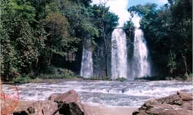
Drai Yong Waterfall is located in Ea M’nang commune, Cu Mgar district and Cuo Knia commune, Buon Don district, 22 km from the center of Buon Ma Thuot city to the Northwest. Drai Yong Waterfall was ranked National Monuments in Decision No. 823/Decision -The Culture and Sports Culture on March 9, 2017 of the Ministry of Culture, Sports and Tourism. The total area of the relics protection area: 83.62 ha (Area I: 5.83 ha; Area II: 77.80 ha). In Ede, Drai Yong Waterfall, meaning "Thunderstorms" or "strong waterfall". This is a beautiful waterfall located in the middle of the Ea Tul stream - a stream originating from Kǒ Kpo stream, Krong Buk district. Ea Tul stream has the flow from east to west, finally flowing into the Serepok River. On his flow, this stream creates three beautiful waterfalls: Drai Kroa, Drai Yong and Drai MPI. In this waterfall system, Drai Yong is the most poetic and majestic waterfall. The upstream of Drai Yong is a nearly 100m wide stream, 48 northern banks are bamboo bushes, half -growing pineapple and regenerated forests that are planted by local authorities to restore landscape and create an environment for the monument. The southern banks are smooth green lawns and lush corn fields. When there was only about 10m from the waterfall, the water from the upstream suddenly swirled back, suddenly broken down a deep valley to create the Drai Yong waterfall. The place where the waterfall has a width of about 80m and a height of about 12m, the water is swirling to create sounds that echo the whole area. Steam, dust from the white, blind flying waterfall like the fog floating in the air, when the sun shines through this steam becomes a dazzling rainbow band in the morning sun. The landscape of Drai Yong Waterfall is a component of the relics of Cu Mgar district and Buon Don district. With a poetic natural landscape, fresh and airy air, Drai Yong Waterfall is an ideal tourist destination, which has a great attraction for enthusiasts of outdoor picnics, wanting to find nature to dispel stress, fatigue after heavy labor days in urban areas that are stable, bustling and dusty. In addition, the ecosystem around the waterfall also preserves many pristine features, close to the center of Buon Ma Thuot city, the traffic is relatively convenient for tourists inside and outside the province as well as international visitors to visit, experience and explore at this scenic name. Source of electronic portal of Cu Mgar district, Dak Lak province
Dak Lak
3651 view
Rating : National relics.
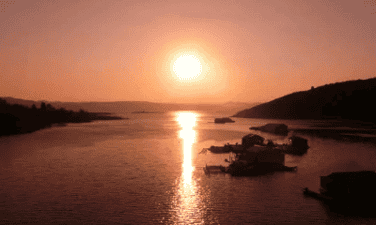
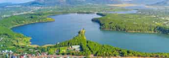
The relics of Ho Lak landscapes
Ho Lak in the language of the Mnong people, the word "Lak" means "water". Ho Lak also known as Lac Thien Ho, located in Lien Son town, Lak district, 56km south of Buon Ma Thuot center on Highway 27 to Da Lat. Lak Lak has an area of more than 500 hectares, this is one of the largest natural lakes in Vietnam, the southwest of the lake with the Krong Ana River (Wife River) is one of the big rivers of the Serepok stream, the west of Lak Lake is the majestic ču Yang Sin sequence like the chest of the strong guy shielding the lake of the four -season lake of the mountain. From the top of Lac Thien Pass of Yang Ro Buon in Lak Yang Tao commune, we will see the lake appears with a splendid beauty - clouds, water, hills, mountains, fields mixed together as a picture of water. Ho Lak is also associated with the legend of the fire and water of Mnong people. The story is that: The day has been, in the past, it was a long time ago, not knowing because of the reason for the god and the fire god suddenly contradicted each other. After a battle, the god lost the battle to enter a rock. Since then, drought began to occur, in a few years, there was no rain, trees and animals died. The villagers face up to the sky, the sound of the resentment. One day, there was a poor boy leaving, determined to find water for the village. He kept going, going forever, once tired, the boy sitting on a rock with an eel lying curled up. He made the eel brought back in a pot, the next morning he suddenly saw a drop of water from the eel's mouth released, stagnant at the bottom of the pot. He felt that: The water god here!. He dropped the eel and kept following the eel mark and went, went forever, until the eel disappeared, it was just a vast lake that appeared before his eyes. The boy rubbed his eyes once, twice, then once again dared to believe that he was not dreaming. Lak Lak has from there. Today, Ho Lak is an attractive tourist destination, coming here visitors will be riding elephants, sailing, learning about the traditional customs and traditions of the Mnong ethnic community at the Mlieng Trading - one of the preserved ancient traders of the province. Besides, Lak Lake is also a large fish bowl of the province, a source of abundant fisheries to serve the lives of the people. In particular, on the top of the hill next to Lak Lake was built by King Bao Dai to rest and watch the landscape. Palace is currently restored and exploited by Dak Lak Tourism Company to serve tourists. On 11/5/1993, Ho Lak was recognized as a national landscape monument. Source of electronic portal in Dak Lak province
Dak Lak
3719 view
Rating : National relics.
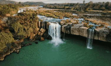
Dray Thuong Waterfall (Gia Long Waterfall)
Dray Thuong Waterfall is located on the Ea Krong River, next to Kuop Buon in Ea Na commune, Krong Ana district, 18km south of Buon Ma Thuot city center. From a distance, Dray Thuong Waterfall stands out a white color on the silver water of the Ea Krong River. The two sides of the river are a vast green of the mountains. Right at the waterfall area, a very majestic image, strong impression that is the image of the Ea Krong river, with the water floating on the upstream, suddenly folded by a stone shelf across the river, about 70m wide. The rushing water in the abyss is about 08m high, echoing a corner of the forest. In the rainy season, the water is filled with the river, we only see a giant, intense waterfall. However, in the dry season, the water flow is completely, forming 09 different large and small waterfalls. Of the 09 waterfalls, there are 05 waterfalls located in the middle of the river from 05 to 10m apart, there is a rumbling water, but there is a gently murmuring water. Dray Thuong Waterfall has since become the love and attachment of the indigenous people here. Expressed through the ancient ancient story of the Ede people full of poetic, about the legend of this Thuong Sung Waterfall. The story says: In ancient times, in an Ede village, there was a very beautiful girl named H’mi, she loved a tall, healthy and gentle boy. Every day, the couple often invite each other to work. One day, after finishing the field, the two invited each other to rest on a rock under the ancient tree. When they were sweating and sweating, they saw a monster, their heads were as big as the mountain, their eyes were like a copper pot, a long beard with their arms, her hair was as sharp as the name, the whole body covered with a white scales, sparkling like silver. The monster flew up to the sky and suddenly fell to the ground like crows grabbing the bait, his legs kicked hard to make a large land sinking and there a giant water column sprayed violently, dragging H’mi was terrified, and her lover was swept away. The boy like a tiger trying to pull his lover but despair, watching his lover disappear into the fog, and sparkling white scales. Since then, the boy turned into a large tree trunk, the root was deep into the rocky rapids, the body of a suffering person who was struggling. And the huge water column turned into Dray Thuong waterfall today. And, at the other end, H’mi was still loyal to crying and crying day and night to reclaim her lover. In addition, Dray Thuong Waterfall is also associated with the following historical event: In the 1930s - 1933, the French colonialists mobilized the people and political prisoners at Buon Ma Thuot's exile house very hard and hard under their torture, torture to build an arc cross through the waterfall along with the hanging bridge across the Ea Krong River. Today, we still see the two sides have two bridges that the French colonialists have built, this is the most convincing history of the cruelty of the French colonialists at that time, there were countless people and political prisoners abandoned the bodies in the forest and abyss. And here, it is also a challenging place, practicing the gods and the will of revolutionary struggle of patriotic communists. On January 4, 1999, the Ministry of Culture and Sports issued Decision No. 01/1999/Decision -The Culture and Sports Culture recognized Dray Sap Thuong Waterfall as a national landscape monument. The management area of the waterfall is 277.5 ha. Source of electronic portal in Dak Lak province
Dak Lak
3739 view
Rating : National relics.
Thuy Tien Waterfall
Located in Giang Tien village, Ea Puč commune, Krong Nang district, about 56 km from the center of Buon Ma Thuot city. Originating from the streams in the deep forest with 4 main waterfalls, each waterfall has its own beauty. Thuy Tien is like a fairy hidden by the mountain forest with the peaceful waterfalls winding among the thousands. Coming to Thuy Tien waterfall, we will be released in the sound of the stream, watching the fanciful picture of nature on both sides of the waterfall, with the cliffs stood up to the middle of the sky, and countless flowers, butterflies, birds, animals. Not only known as a charming painting, but the waterfall is also associated with the ancient folk story of the Ede people. The story is that: In the old days, in an Ede village, there was a boy named Dam Ji, an extraordinary appearance, his limbs solid like stone. Ji is good at hunting, every sword of him is a terrifying animal, but his personality is very impatient and aggressive, if anyone does not mean his intentions, he immediately punish him, so even though he is very talented, he is not admired by everyone, whereas his younger brother is gentle and kind, so he is loved and appreciated by his people. One day, the two brothers went to the forest to hunt for animals, had not hunted any animals but the mouth was thirsty, there was no drop in the forest to drink. While despairing because of thirst, holding the sword in his hand, the hot ji swung on the ground, the sword had just stabbed to the ground and suddenly shook the earth and a stream appeared in front of him, he shouted happily because there was a country to save thirst. He reached out and swung another seven sword to the ground, then at the distance not far from the stream, the wandering, very shaking, the animal panic, he came to see the appearance in front of a stream. Since then, in the forest that the boy often comes to hunting with two streams and streams in the west, everyone named Ea Dah and the east stream are named Ea Puč. But these two streams have two different personalities just like the two brothers Dam Ji. Ea Dah stream in the west has the same personality as the British, very brave and intense. Referring to the name of this stream, people in the area are terrified, if they come here to catch fish, find drinking water to be very wary of air, which will be swept away by the stream, children in the area down to the shower are often lost by the stream. Those who come here to catch fish and praise this stream many new fish to catch fish, if they say this stream has little fish or no fish, the stream will not give the fish, can catch the whole day they will not get any fish. When the angry stream will rise, it will cause floods to get drifted. In contrast, the Ea Puč stream in the east is very peaceful and does not harm people, whoever comes here fishing, catching fish leaves with shrimp and fish full of baskets, so people call the Ea Puč stream as the Hien stream. The stream is like a gentle and kind younger brother who often helps others, unlike the ferocious Ea Dah stream. Besides, Thuy Tien Waterfall is also associated with the beautiful love story between Uncle Ho's army and a beautiful Ede ethnic girl, both bravely fought against the enemy to the last breath to protect the village, protect the revolutionary zone, contributing to the victory of the resistance war against the US to save the country of our people. On March 3, 2009, the Ministry of Culture, Sports and Tourism issued a decision to rank Thuy Tien waterfall as a national landscape. Source of the provincial web portal
Dak Lak
3425 view
Rating : National relics.
Drai Kpôr waterfall
Drai Kpo Waterfall of Buon Trung (often called Buon M’Toi) commune ču Bong, Ea Kar district, about 100km southeast of Buon Ma Thuot city center. In Ede language: Drai means waterfall, Kpro means souls, spirituality, Drai Kpo water, which means "Soul Waterfall", "Spirit Waterfall". The waterfall has long been attached to the lives of the Ede people in the ču Yang in respect for respect, the place of Yang (the god) reigns, for the cool water, for the green forest and bringing life to the villagers. Dray Kpo Waterfall is originated from the Cu Yang (Mountain) range of 769m high, the Dray Kpôr line is the conformity between Ea Kp Dam and Ea Kpir streams from the č kdroah sequence with an altitude of about 700 m, stretching over 100 m wide, reaching about 50 m, from here the water circuit weaving through the stone slot and then the height of the small circuit is down to a small circuit down to a small valley. Broken to create waterfalls up to 30 m high then joined in the Krong Pac river. The waterfall is the continuation of 4 waterfalls, each with its own appearance. Surrounded by primeval forests with many rich flora and fauna. The 500m from the Buon Buon Base is from 1960 to 1975, which marks the revolutionary miracles during the anti -American resistance war. The story says: In the 1960s of the last century, the US - Diem advocated to further implement the war strategies for South Vietnam. Therefore, when the Act 10-59 is enacted. The strategic hamlet conducted throughout the territory, since this side of the 17th parallel. The Central Highlands is not out of that campaign. And Buon Trung is one of the places where the "tactical" intention of Mi Dan used the upper people as the core force (Furo force) to eliminate the communists lying thoroughly used. The revolutionary Base of Dray Kpor was born in the middle of the fire of war. At the same time, a Liberation Army unit was also born (taking the name H1) and stationed right at the foot of Dray Kpôr waterfall. When discovering this base, the United States - Wei repeatedly conducted white terrorists, Buon Trung continuously burden the bombs from the sky. In addition to the poetic, majestic natural scenery, attached to the resistance monuments and close to the village, Drai Kpôr waterfall also provides water to serve irrigation for Buon Trung fields. On December 15, 2004, the Ministry of Culture and Information (now the Ministry of Culture, Sports and Tourism) issued Decision No. 105/2004/Decision -The Culture and Sports Culture Ranking of Drai Kpôr waterfall as a national landscape monument. Source of electronic portal in Dak Lak province.
Dak Lak
3418 view
Rating : National relics.
The resistance base of Dak Lak province (1965 - 1975)
The resistance base of Dak Lak province (1965 - 1975) is a place to mark important historical events in the tradition of national struggle and defense of the people of the ethnic groups of Dak Lak province. This place is not only a communication line, transition from the North to the rear in the Central region to the southern provinces but also the place where Dak Lak Provincial Party Committee and other units in the province chose as a basis, living and revolutionary activities. In particular, the base area is also the place where 3 times the Congress of Dak Lak Provincial Party Committee: The third time (1966), the fourth time (June 1969), the 5th time (November 1971); A corridor to transport officials to strengthen the Central Highlands battlefield in the years 1968 -1973. On December 29, 2023, the Ministry of Culture, Sports and Tourism issued Decision No. 4241/Decision -The Culture and Tourism Culture and Tourism on the ranking of the National Monuments for historical monuments of the relics added to the resistance base of Dak Lak Province (1965-1975), Hoa Le, Hoa Phong, Cu Pui, Yang Mao and Cu Don, including 39 locations. According to the leader of the Department of Culture, Sports and Tourism, the historical sites of the relics added to the resistance base of Dak Lak province (1965-1975), Hoa Le, Hoa Phong, Cu Pui, Yang Mao and Dam Dam are one of 43 relics rated historical, cultural and famous landscapes of the province, valuable and great meaning in history, cultural, historical, scientific and historical; expressing gratitude to the generations of his father sacrificed for the cause of national liberation and national defense; Contributing to educating revolutionary traditions, patriotism and national pride of the people, especially for the younger generation. Source of electronic portal in Dak Lak province
Dak Lak
3682 view
Rating : National relics.
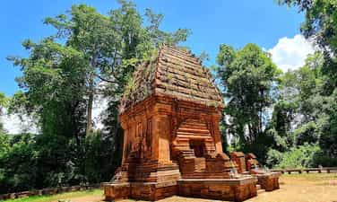
Yang Prong Tower
Cham Yang Prong Tower of Ea Rok commune, Ea Sup district, about 100km west of Buon Ma Thuot city, also known as Green Forest Cham Tower. This is one of the only indigo towers in the Central Highlands built in the late 13th century to worship Siva god in the form of Mukhalinga (great god), praying for the flourishing of the race and happy happiness. Yang Prong Tower, also known as the Green Forest Cham Tower, is a Cham tower located in Village 5 Ea Rok commune, Ea Sup district, Dak Lak province. Legend has it that the tower is the tomb of the head of the old Cham village. In 1906, it was found on the stone frame of the tower of the ancient steles of the Cham king in the late 13th century. The material vestiges around Yang Prong seem to prove this is a old manager of the Cham people in the Central Highlands. The tower is quite intact, higher than 10m, built of hard bricks with many different sizes. The tower has a square jar, the eastern lobby of 1.60m wide. The structure of the square tower, the upper point is like onions, different from the usual Cham architecture. In 1990, many domestic and foreign scientists came to and there were a number of tower research. The scientists all asserted: Yang Prong was built in the 13th century, proving about 700 years ago, the Central Highlands not only had indigenous people but also other ethnic groups. Yang Prong is a monument of great significance for ethnologists, history, architecture ... The tower was built at the end of the 13th century under the reign of Sinhavarman III (Che Man), worshiping Shiva in the form of Mukhalinga, praying for the development of the race, and happy happiness. The Tower of Prong was discovered in the 1904-1911 years by a French ethnicist named Henri Maitre. The scientist described this project in Les Jungles Moi (all forest) published in Paris in 1912. Yang Prong Tower is a red brick architectural block on a blue stone high floor. The tower has a height of 9m, the square bottom is 5m long, each outside is 3 fake doors, a single door opens towards the East direction, where the reign of the gods. Above expanded and soaring pen pyramid, different from the architecture of other Cham towers in the Central. During the war, the tower was searched by gold and mines, so it was much damaged. The tower is also not built on high hills, low mountains without trees like other Cham towers but lying under the ancient canopy of the Ea Sup forest and the peaceful Ea H'leo River. Yang Prong means a great worship tower, a god who specializes in managing crops according to the concept of the ancient Cham people. This is an unfinished project, because when building a tower, Cham people never build one but often a population. Currently, the tower has been recognized as a cultural heritage that needs to be preserved. Despite being embellished, the tower generally retains its ancient and solemn features. Around the tower is surrounded by many years old, quite dense, this is also a testament to the protection efforts of the local government. Not only is a unique artistic architecture, Yang Prong tower has a mysterious ancient Cham nuance and culture, steady ancient existence and sustainability at the same time. On August 3, 1991, the tower was recognized as a national architectural and cultural relic. Source of electronic portal in Dak Lak province
Dak Lak
3684 view
Rating : National relics.
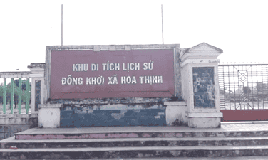
The venue for the co -prosperity
Dong Khoi historical relic area of Hoa Thinh commune is the place to display historical images of Dong Khoi day of the people of Hoa Thinh commune. This is also a place to educate the revolutionary tradition of the commune for young people today and tomorrow, and to serve visitors to learn the meaning of the historical meaning of the Hoa Thinh commune day. This is a national historical monument area by the Ministry of Culture and Information with Decision No. 2005/Decision -Culture and Information on November 16, 2005, ranking the National Monument "The venue for the co -prosperity". Facing the requirements of the new revolutionary struggle, in January 1959, the Party Central Committee issued Resolution No. 15 to determine the basic tasks of the Southern Revolution as "liberating the South from the yoke of the empire and feudalism, the implementation of independence, democracy and plowing farmers, completing the people's democratic revolution in the South", "the basic development path of the Southern revolution is the authorities." Under the light of Resolution 15 of the Party Central Committee, the revolutionary movement in Phu Yen province moved to a new development stage. In September 1960, the first Congress of Phu Yen Provincial Party Committee was held at the Lo Lo base (Dong Xuan mountainous district) to set out the policy and measures to promote the Dong Khoi movement in the plain, recruiting young people to build armed forces, build base areas and mass facilities ... Mr. Duong Du, a historic witness, is one of the revolutionary officials who have emoted the Dong Khoi, the system of the Dong Khoi, the system of Dong Khoi Khoi. After studying, thoroughly grasping the Resolution of the 15th Central Party Conference and preparing forces, at 19:00 on December 22, 1960, the force participating in Dong Khoi started marching from slope to look through the villages and hamlets and then divided into three wings to the headquarters of Hoa Thinh commune, shooting on the enemy's defender platoon. Due to being mobilized before, when listening to gunfire, thousands of people from the directions poured out the road, carrying sticks, spears and armed forces of the district both attacked and rebelled to arrest the Wei Wei, and then focused on the headquarters of Hoa Thinh commune to attend the rally. The force participating in Dong Khoi arrested the vice-deputy representative to hand over the seal, papers, documents ... About 1 am on December 23, 1960, the rally began. The people chanted the slogans: "The American imperial island and the puppets", "The South Vietnam Revolution is definitely successful". At 3 o'clock the same day, the rally ended. Hoa Thinh became the first commune of Zone 5 Delta owned by the revolutionary government. From Dong Khoi Hoa Thinh, the revolutionary force continued to destroy evil and alkaline in the communes of Hoa Dong, Hoa Tan, Hoa My and Hoa Hiep. The liberation area of Phu Yen province expanded with more than 20,000 people, the movement of raising troops, contributing to the revolution to develop more than ever. Also from Dong Khoi Hoa Thinh, thousands of young people of Phu Yen volunteered to join the Liberation Army, escaped into the base, traveling throughout the battlefields of Khanh Hoa and Dak Lak on duty against the US, Wei and Save the country. Source of the website of Hoa Thinh commune, Tay Hoa district, Phu Yen province.
Dak Lak
4015 view
Rating : National relics.
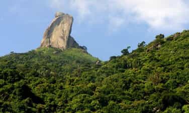
The monument of rocky mountain
Da Bia Mountain is located on Deo Ca mountain range, south of Dong Hoa district. 706m high mountain, east with Ba Ba Hon close to the sea, the foot of the western mountain is National Highway 1A, north with Dong Son mountain, the foot of the southern mountain borders Vung Ro. Stone ridge is very steep with many rocky rocks, overgrown trees, roads to the top are quite hard. On it a tall block of stone is called beer stone. Depending on the perspective, you can see stone beer with different physique. At the top of the mountain, there is a high slope, seeing beer stone like a lion lying down the ribs. At the Hao Son junction - Han Dam looked up, stone beer was like Nhan tower. From Bai Xep - Bai Bang (Hoa Tam commune) looks at, stone stone is like a sitting. At Hoa Tam Truong, looking at stone like a standing Buddha, it can also be said that the monk is down the mountain. At the foot of the mountain, there is Tien beach. In Phu Bien Tap Luc, Le Qui Don wrote: “Da Bia Mountain in Phu Yen is the precursor of the boundaries with Chiem Thanh, the mountain is very far away, the watershed of the coast. This mountain is higher than another mountain. When Holy Tong beat Chiem Thanh to take this land into Quang Nam, set up the old Chiem Thanh lineage, Phong for the land to return to the west, sculpted the peak of the mountain to set up the boundary, his back turned to the north, facing towards, facing towards, facing towards, facing toward Nam, for a long time, the word has been worn out ”. The book of Dai Nam unanimously wrote: “Considering the book of Luc Trinh Chi Chi of Tran Cong Hien, the paragraph is that: This mountain has a limb to the sea, dividing two streams of water, plants and plants, there is a large stone spinning. East head as shown. When King Le Thanh Tong went to fight Chiem Thanh through that mountain, sadly lamented: "Since the time of the early sky, the boundary was divided, because of the inverse of heaven, it had to suffer from heaven." The king made the word touch on the rock. Did King Le Thanh Tong are engraved on the rocky mountain? People still consider it a legend, marking the historical turning point of the land of Phu Yen. Because in Dai Viet historian, there was a journal of the King's Nam Chinh record as follows: "On the first day of March of the New Year of the Rabbit, the 2nd Rabbit, the 2nd day, went down to the army." In 1937, there was a survey of the stele mountain of Tri Tuy Hoa government at that time Nguyen Van Tho. In recent years, there are surveys of young people and students of Phu Yen, they have not found any traces. Rock Mountain (also known as Thach Bi Son) is 706m high, majestic in the north of Ca Deo Rang. On the top of the mountain is a giant 76m high rock block, with strange shapes, early in the morning or in the afternoon, there is often white clouds covered around, when hidden when appearing. Bia Da mountain was recognized as a national landscape monument in 2008. Source of the portal of Phu Yen province.
Dak Lak
4116 view
Rating : National relics.
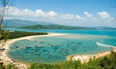
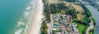
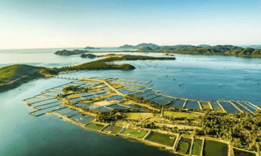
Xuan Dai Bay
Xuan Dai Bay is located about 45km from Tuy Hoa city to the north with a green area, charming painted paint contains many important historical events related to Phu Yen land. With an area of more than 13,000 hectares, Xuan Dai Bay is located in Song Cau and Tuy An districts. Surrounding the bay are high mountains and also part of the Truong Son mountain range stabbed straight to the sea. In the east there is Xuan Thinh peninsula starting from the Luong Luong Pass to the East - South hugging Xuan Dai Bay. Xuan Dai Bay is also a place to witness many important events associated with the 400 -year history of establishment and development of Phu Yen. At the end of the sixteenth century, the first Vietnamese followed Mr. Luong Van Chanh to Phu Yen to choose favorable lands along the estuaries and estuaries to make the living area. These are the areas of Cu Mong, Ba Dai, Da Dien and Da Nong. A document dating back to 1597, stored at Luong Van Chanh Temple, said: From the paint area, the bottom is to the estuaries, together to set up houses, exploit wasteland into garden fields, go through 3 cases, pay tax as usual ”. The Ba Dai area at that time was included in Xuan Dai Bay and lowering the Cai River belonging to Tuy An today. This area has both fertile farming area thanks to the alluvium of Cai river, and has a airtight bay that is convenient for anchoring fishing boats to catch seafood. From the first settlements, the Vietnamese people expanded their living areas, mastering the sea, plains and large mountains in the west, turning this large area to become rich and busy. . It was also an important basis for the early seventeenth century, the area of Xuan Dai Bay became the administrative center of Phu Yen. In 1629, the capital of Phu Yen, Hoi Phu, was built at Tien Chau gate right on the banks of Xuan Dai Bay, the place where the old historian was built, there was a mountain of Xuan Dai nearby. During the fighting period between the Tay Son Dynasty and the Nguyen Dynasty, Xuan Dai Bay became a battlefield with many major naval battles. In June 1775, after the Tay Son army owned Phu Yen land, the general of Lord Nguyen, Tong Phuoc Hiep, commanded more than two thousand troops to regain this land. The army of Tong Phuoc Hiep mainly stations in the area of Hoi Phu and Xuan Dai Bay. In order to deal with the army of Tong Phuoc Hiep, General Tay Son, Nguyen Hue at that time, was only 23 years old, brought a army along the mountain road in La Hien in combination with the on -site force and suddenly attacked Tong Phuoc Hiep's army. Quickly disintegrating, Xuan Dai Bay became an important Marine base of the Tay Son family. By the last years of the eighteenth century, when the forces were growing, Nguyen Anh often pulled troops from the south to harass Tay Son and Xuan Dai Bay to become a fierce fighting battlefield. At the end of the nineteenth century, the uprising responded to the Can Vuong movement led by Le Thanh Phuong in Phu Yen. In June 1897, the expeditionary army under the command of Chevreux, Tirant and Tran Ba Loc landed in Xuan Dai Bay to suppress the uprising. The base of the insurgency stationed in Xuan Dai Bay led by Bui Bui was lost, two weeks later the uprising was extinguished. In April 1945 the Japanese Navy ships entered Xuan Dai Bay to conquer to make a stepping pedal into the mainland, but were sinked by the Allied aircraft in the middle of the bay. The hull sinks in the deep water, leaving only the flagpole and the observatory. Until the late 80s of the early 90s of the twentieth century, there were still traces in the Wing Chun. Xuan Dai Bay is also the place where the first diplomatic activity between Vietnam and the United States. Xuan Dai Bay area is also the homeland of celebrity Dao Tri. He used to serve under the dynasties of Minh Mang, Thieu Tri and Tu Duc. Dao Tri once held the positions of the capital and General Ha Ninh (Hanoi, Bac Ninh). So far, historical events have gradually retreated to the past, but the evidence of a heroic time still saved the seal in the area of Xuan Dai Bay. Experiencing many ups and downs of history, Xuan Dai Bay is now entering a new period of development, commensurate with the inherent strengths of a national scenic monument. On November 20, 2011, Xuan Dai Phu Yen Bay was ranked by the Ministry of Culture, Sports and Tourism. Source of the portal of Phu Yen province.
Dak Lak
3812 view
Rating : National relics.
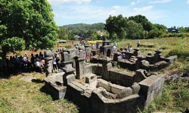
Tomb relics and location of Dao Tri temple
The tomb and location of Dao Tri temple is a testimony of a historical celebrity of Phu Yen land, participating in important historical events of the Vietnamese nation in the nineteenth century. Dao Tri was born in 1799, died in 1879, in Vung De, Tan Thanh Quarter, Xuan Dai Ward, Song Cau Town, Phu Yen Province. He came from a fisherman's family, specializing in living by fishing. But with the smart and intelligent nature, he became one of the most advanced martial arts officials in the Nguyen army system; In turn, all three dynasties of the Nguyen King, Minh Mang, Thieu Tri and Tu Duc. In the 21st year of Tu Duc (1868), Dao Tri was promoted to the army of the capital. Dao Tri is both a martial arts martial arts with illustrious feats, and a great god who has a lot of merits in ruling and educating the people, and being praised by King Tu Duc, giving a reward of Kim Bai with the word " The virtue, the people ”, wrongly, the mandarin writes the epitaph recorded the merit of the merit ... Dao Tri died at the age of 80 years old (1878) in his hometown of Tan Thanh village and was worshiped by Descendants. Currently, Descendants of Dao Tri in Tan Thanh village is the last is the 5th generation, Mr. Dao Van is the oldest. Mo Dao Tri is now located behind Tan Thanh village, on the northeast of Hon Vung mountain, with a height of 20m above the sea surface, about 300m from Highway 1 A. The tomb faces the north, the scale of building the superficial place, the tomb and the fence surrounding the surrounding fence, the tomb covered with elephant -shaped mushrooms, the front has a room ... , about 1km from the grave to the north. The temple of Dao Tri was devastated by the war, the remaining traces had only an area of 7.2 core 8 meters and a phosphorus project was covered with moss with time ... With those values on July 2, 2015, the tomb and location of Dao Tri Temple has been ranked as a national monument under Decision No. 2247/Decision -Culture and Sports Culture Tourism Source of the portal of Phu Yen province.
Dak Lak
4111 view
Rating : National relics.
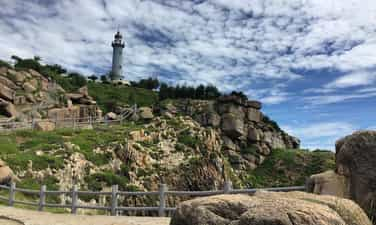
Landscape Area Bai Mon - Mui Dai Lanh
The landscape of Bai Mon - Mui Dai Lanh is located in Dong Be village, Hoa Tam commune, Dong Hoa district, Phu Yen province), about 35km southeast of Tuy Hoa (Phu Yen). Characteristics: This is a place to converge many beauty of nature with forests, sea, streams and hills. There is also a night lighthouse to help boats and boats back and forth on the sea and into Vung Ro Bay. Dai Lanh's tip was created by Dai Lanh mountain range - a branch of the Truong Son mountain range, stabbing into the East Sea. The Great Cape was discovered by a French general Varella at the end of the 19th century. Varella realized the important role of the Great Cape on the international map. Therefore, on the old map it is called Cap Varella (Varella's tip). The special feature of Dai Lanh's nose is that it looks like a mountain like an island because there is a fresh water stream separating it out of the mainland but actually it island. The landscape in Dai Lanh mountain has been listed as beautiful landscapes of Vietnam. In 1836, King Minh Mang showed the image of Dai Lanh mountain in Tuyen Dinh - one of the 9 bronze peaks placed at The temple in the inner city of Hue (Thua Thien - Hue). In 1853, during the reign of King Tu Duc, the Great Lanh was in the national dictionary compiled by the court. Local people also call Dai Lanh Mui Mui Dien, because on the top there is a lighthouse about 26m high, at an altitude of 100m above sea level and can signal light goes away from 27 nautical miles. The lighthouse has a cylindrical shape with an average diameter of nearly 5m, inside the pillar is installed 108 wooden spiral stairs to the top. This is one of 8 lighthouses dating back over 100 years out of 79 lighthouses operating in our country. The lighthouse was built by the French in 1890 with the aim of orientation for boats to operate on the sea and enter Vung Ro Bay. The light of the sea was operating for 55 years, and in 1961, it was previously recovered by the Saigon government. However, the lighthouse has not been long, it must be paused because the Great Cape is located in the Eastern base area of the revolution, which is the corridor to welcome numbers. In order to prevent the revolutionary supply route into Vung Ro, the United States bombed the mountains of Vung Ro Bay area, destroying the whole lighthouse station. In August 1996, the State repaired, renovated and the lighthouse officially operated in 1997. At the foot of Dai Lanh's nose is Bai Mon. This is a pristine beach, with a shaped moon with a coastline about 400m long, comfortable slope, fine white sand, crystal clear water. In the west of Bai Mon, there is a fresh water stream. After creeping through many cliffs and primeval forests of the North Pass, this stream flowed across the beach and then poured into the vast ocean. The delicate coordination between nature and the people at Dai Lanh - Bai Mon has created a beautiful landscape complex known to many domestic and international magazines, really the valuable asset of Phu Yen province. In August 2008, the Ministry of Culture, Sports and Tourism issued Decision No. 67/2008/Decision -The Culture and Sports Culture, Ranking of Bai Mon - Mui Dai Lanh landscape (Mui Dien) is a national monument. Source of the portal of Phu Yen province.
Dak Lak
3766 view
Rating : National relics.
O Loan lagoon
O Loan lagoon is located close to National Highway 1A, at the foot of Quan Cau Pass, 22km from Tuy Hoa city. This is a place associated with the Can Vuong movement of Phu Yen province. O Loan lagoon is about 1,200 hectares. Standing on Quan Cau Pass looking down, O Loan was like a phoenix spreading wings, and on the map, O Loan was like a swan that was leisurely flying. West of O Loan lagoon are small hills lying close together. The east is Cao Bien's grave. The folk said that on the way to harm the talented people of the South, Cao Bien was buried here. Cao Bien died in Dong Mon On the paint under the water, the sky buried Cao Bien. In fact, this is not a grave but a sand dunes. Although lying close to the sea, the waves were immense, but thanks to a breeze, the sand was covered with sand, so the graves were down. O Loan is a brackish lagoon, almost entirely in the mainland, with specialties of blood cockles. Under the feudal period, the officials when returning to Phu Yen often went to O Loan lagoon to enjoy the scenery and enjoy the oysters. Other specialties in O Loan are oysters. Tan Da (Nguyen Khac Hieu), a famous poet, has gone around the country, eats everywhere, comes to Phu Yen to taste the delicious strange dish also praised: "Phu fishing fishing, oyster oysters". Oysters live on mangrove rocks, with very sharp edges. Oysters are used to cook porridge, cook soup, stir -fry, but the most delicious and attractive are pale oysters or oysters mixed with peanuts and tomatoes. Delicious dishes in O Loan also have crabs, also known as Huynh De or Emperor. The emperor's apricot or dark yellow, as soon as the crabs are still in the water, there is a bunch of yellow, short hairs behind. In particular, this crab does not crawl to crawl, because the more and more sticks grow in front of the head. In addition, O Loan also has shrimp, silver shrimp, squid, jellyfish, jelly, and message. In the middle of the lagoon, there are two large rocks overlapping called Hon Chong. O Loan's green landscape is an endless source of inspiration for poets to compose. Poet Nguyen My wrote: The sea entered O Loan asleep Blood cockle is born in the bottom of the matte green well. Poet Xuan Dieu wrote the poem of O Loan lagoon: O Loan lagoon, O Loan lagoon. The Kingdom of the Kingdom with the cloud The dress, the wings of the birds are open Cool air spread beauty High and low hill around the brocade Luc embroidered with blue Cassava good potato Corn cane looks away from a color .... Every year until the 7th of January of the lunar calendar, the fishing festival of the fishermen in O Loan lagoon is held. Tens of thousands of people from all over the world attended. This is a beauty of Phu Yen traditional folklore. O Loan lagoon has been ranked by the Ministry of Culture and Information (now the Ministry of Culture, Sports and Tourism) as a national monument. Source of the portal of Phu Yen province.
Dak Lak
3833 view
Rating : National relics.
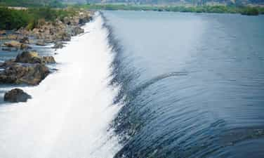
Cam Cam Dam.
Dong Cam dam project is located on the Ba River in Phong Hau village, Hoa Hoi commune, Phu Hoa district (the north bank) and Thanh An village of Son Thanh Dong commune, Tay Hoa district (the south bank), officially started construction Built in 1924 and was inaugurated on September 7, 1932, including a system of focal points and led ditches. When the irrigation system of Dong Cam, all agricultural production in Tuy Hoa Delta has a growing step. From a plain area, only a precarious crop becomes a rich plain area with 2 to 3 rice crops, high productivity, bringing a happy and happy life for the people of Phu Yen. During the resistance war against the French colonialists, thanks to this project, Tuy Hoa Delta was like the "resistance stomach" of the South Central and Central Highlands freedom. The French colonialists used many tricks to destroy this irrigation system but the army and Phu Yen people bravely "broke" the scanning of the enemy to create a famous battle of Ba - Truong Lac river; firmly protect the focal point of the Cam and the crucial works. For a long time, Dong Cam irrigation system has been considered a "homeland" to be ingrained in the memories of people in Phu Yen. So far, Dong Cam Dam is still considered a model of technical construction of irrigation works for agricultural production. Not only that, Cam Dam is a prominent landscape on Ba River. The above natural elements have made the Cam Dam Dam area is one of the charming and attractive natural landscapes of Phu Yen. It has become a tradition, on January 8, tens of thousands of people eagerly offer incense, participate in the Dong Cam Dam festival to honor and remember those who have contributed effort and blood to build this work, Demonstrate the morality "Drink water to remember the source". With the extremely meaningful historical, cultural and natural landscape values, Cam Dam has been ranked by the Ministry of Culture, Sports and Tourism as a national sight in Decision No. 2085 September 5, 2022. Source of the portal of Phu Yen province.
Dak Lak
3812 view
Rating : National relics.
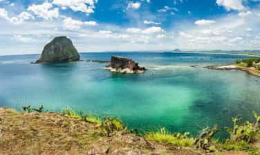
Hon Yen population
According to a source from the Department of Cultural Heritage (Ministry of Culture, Sports and Tourism), the landscape of Hon Yen complex (An Hoa commune, Tuy An district, Phu Yen province) has just been cultural and sports by the Ministry of Culture and Sports And tourism recognition is a national monument. The Ministry of Culture, Sports and Tourism requests the People's Committees at all levels where the relics are rated to perform the state management of monuments in accordance with the law on cultural heritage within the scope of The case and powers. The landscape of Hon Yen complex is an area including Hon Yen, Hon Don (Hon I iron), Than, Ganh Yen, Hon Choi, Vung Choi forming a natural landscape complex on the beach. In particular, Hon Yen is a prominent highlight of this landscape complex. According to the Department of Culture, Sports and Tourism of Phu Yen Province, this is a very natural landscape from geology to flora and fauna, biodiversity; have cultural and historical values; has the potential for attractive coastal tourism development. Source of the portal of Phu Yen province.
Dak Lak
3784 view
Rating : National relics.
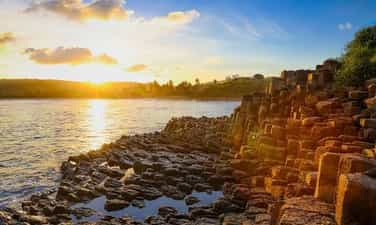
Discon stone
On December 31, Deputy Prime Minister Vu Duc Dam signed a decision to rank special national monuments (phase 11 in 2020) for 07 monuments, including the landscape of Ganh Da Dia, Tuy An district. , Phu Yen province. Ganh Da Dia is an interesting natural landscape of the landscape and unique geology in Vietnam, this landscape is located in An Ninh Dong commune, Tuy An district, Phu Yen province. As a collection of prismatic stone pillars arranged, the other is connected to the other with water waves. The rocky beach spreads together with mysterious black. There is a vertical pillar, with a tilted pillar but still piled up on the floor looks like a husband's husband, so it is called a stone stone. From a distance, Ganh Da looks like a huge honeycomb. Badan stone columns of discs are thought to be formed by the researchers millions of years ago, when the molten lava lines spit out from volcanoes in Van Hoa plateau (30km from 30km) to meet cold sea water, so Freezing and cracking. Ganh Da Dia is one of the most attractive landscapes in our country, which was ranked by the Ministry of Culture, Sports and Tourism in 2005. This landscape. Source of the portal of Phu Yen province.
Dak Lak
3823 view
Rating : Special national monuments.
Historical site of the Ngan Son - Chi Thanh massacre
After the Geneva Agreements were signed, the US imperialists and their lackey regime Ngo Dinh Diem still deliberately violated the Agreements. In Phu Yen, on September 7, 1954, three companies of the 10th battalion of the Vietnam National Army (treasonous puppet troops) came to Ngan Son to take over. Company 1 was stationed on the national highway, company 2 was stationed east of the elementary school, company 3, commanded by Captain De, was stationed at the school. Captain De went behind the school, entered Mr. Banh Lien's house and saw a photo of President Ho Chi Minh on the altar and immediately took it down. Mr. Banh Lien's wife was sweeping the yard at that time and used a broom to hit this officer. He got into a fight with the homeowner. The whole family cheered together. Many people ran, and after a while people from the Ngan Son, An Thach, An Dan... regions came to protest against the Vietnamese Nationalist soldiers. Suddenly, Captain De (the book History of the Party and People of Chi Thanh town wrote that his name was Vo Duy De) ordered his soldiers to shoot directly into the crowd in the school yard. Nine people were hit by bullets and died on the spot, while ten others were injured. The people were extremely indignant, causing Vietnamese Nationalist soldiers to hastily withdraw into Chi Thanh. The Vietnam Labor Party's base operates secretly in Ngan Son to mobilize people to carry the dead and injured into Chi Thanh to continue fighting with the Vietnamese National government. At this time, the people of An Ninh, An Dinh, An Cu... communes also flocked to support the struggle. From Nha Thuong slope (now north of Truong Xuan quarter, Chi Thanh town), Vietnamese Nationalist soldiers placed machine guns and shot straight at the group of people from the direction of An Ninh. A series of people collapsed into the fields. People from An Dinh who came down were also shot dead by soldiers, many others also collapsed at Truong Giac Pagoda (now in the stadium area of Tuy An district). On the afternoon of September 7, 1954, 79 people died and 76 were injured. People's anger is increasing day by day. On September 7, 1954 (ie August 11, Year of the Horse), the people of Ngan Son - Chi Thanh in particular and the people of Phu Yen in general will never forget these landmarks: Truong Ngan Son - the first point massacre broke out; Nha Thuong slope and the district People's Theater area - where enemies frantically shot at the protesters. To commemorate the heroic spirit of struggle and sacrifice of the people of Tuy An district, the local government built a memorial in the center of Chi Thanh town. On June 18, 1997, the Ministry of Culture and Information issued a decision to recognize the place where the Ngan Son - Chi Thanh massacre took place as a National Historical Site. Source: Phu Yen online
Dak Lak
6060 view
Rating : National monument
Outstanding monuments
See all
Le Thanh Phuong Temple
The historical relic of Le Thanh Phuong's tomb and temple is located in My Phu village, An Hiep commune, Tuy An district, Phu Yen province. The relic was recognized as a National Historical-Cultural Monument in 1996. Le Thanh Phuong is the leading historical celebrity in Phu Yen province. He was born in 1825 in My Phu village, Xuan Vinh canton (now My Phu village - An Hiep commune - Tuy An district - Phu Yen province) in a family of Confucian scholars and rich in patriotism. Passing the baccalaureate exam at the age of 30, he returned to his hometown to open a teaching school. In 1885, in response to King Ham Nghi's Can Vuong edict, Le Thanh Phuong stood up and gathered the Phu Yen insurgents to raise an uprising flag against the invading French colonialists. He was appointed "Marshal of Military Affairs" by King Ham Nghi. With Le Thanh Phuong's talent, after only 1 month, he gathered several thousand people to raise the flag of rebellion. At that time, everyone knew him by the title "Marshal of Military Affairs". He divided the combat zone into two zones, one is from Cu Mong pass to Tam Giang pass, the other is from Tam Giang pass to Ca pass. In just a short time, his uprising many times frightened the French enemy. In February 1887, Le Thanh Phuong was captured by the enemy due to an informer. On February 20, 1887 (January 28, Dinh Hoi year), because he could not seduce and bribe him, the Vietnamese traitor Tran Ba Loc ordered the execution of Le Thanh Phuong and many other patriotic scholars at Ben Cay. Coconut (in An Dan commune, Tuy An district today). The uprising organized and led by Le Thanh Phuong in Phu Yen was an important part of the nationwide Can Vuong movement, having a positive and strong influence on the Can Vuong movement in the South Central provinces. Le Thanh Phuong's uprising is a glorious page in the history of the extremely heroic and heroic struggle against foreign invaders for national independence of the Phu Yen people and will forever be the pride of the Phu Yen people. He set a shining example of indomitable will and heroic spirit of sacrifice for the people and country. Le Thanh Phuong's Tomb and Temple relic in My Phu village - An Hiep commune - Tuy An district - Phu Yen province was officially recognized by the state as a national historical-cultural relic in 1997. Since then, it has become a tradition that on January 27 and 28 every year, Tuy An district and An Hiep commune authorities coordinate with the Department of Culture, Sports and Tourism of Phu Yen province to organize a memorial ceremony to the "Marshal of Military Affairs" Le Thanh Phuong, the beloved son of his hometown Phu Yen. This is also an opportunity for people everywhere in Phu Yen province, especially Tuy An district, to gather to participate in traditional activities and organized folk games such as: Pushing sticks, men's and women's tug of war, walking. stilt walking, three-legged running, running and hula hooping, marching while cooking, Chinese chess and human chess competitions, beautiful camping, folk singing competitions, hut card festival and art festival. Source: Phu Yen Tourism Information Promotion Center
Dak Lak
9297 view
Rating : National monument

Luong Van Chanh Temple
Famous man Luong Van Chanh was from Bac Ha. During the reign of King Le The Tong, he was promoted to the position of Thien Vu Ve Do commander. In the year of Mau Dan - 1578, Luong Van Chanh was sent by Lord Nguyen Hoang to stabilize the land from Cu Mong pass to Ca pass. Thanks to his great merits, he was promoted to the position of General of the Fatherland, and later became a Tran Bien Quan. After that, he gathered people from Thanh - Nghe, Thuan Hoa and other places to explore wasteland, establish houses and villages in Cu Mong, Ba Dai and along the Da Rang river. He brought his experience of land reclamation and applied it to Phu Yen. Together with the people, he made this land rich and villages were gradually formed. This was the basis for Lord Nguyen to establish Phu Yen government in 1611. Mr. Luong Van Chanh died on September 19, Tan Hoi year 1611. Luong Van Chanh's grave is located on a high mound, facing the Ben Loi river, towards Chop Chai mountain. Luong Van Chanh Temple is located in open terrain, in front is Ben Loi River, behind is Cam Mountain. On the campus there is also an ancient Bodhi tree with lush branches and leaves, shading an entire corner of the temple, recognized by the Vietnam Association for the Protection of Nature and Environment as a Vietnamese Heritage tree in 2014. To express the admiration and gratitude of today's generation to our ancestors who have publicly established their careers; Demonstrating the moral principle of "Drinking water, remember its source", meeting the wishes and expectations of officials and people in the province and the whole country, Phu Yen Province has cast a statue of famous man Luong Van Chanh to worship at the temple of Phu Yen. His statue is cast in bronze with a height of 1.4 meters, sitting on a chair, holding a decree, placed right in the main hall of the temple, showing solemn respect. Every year, on February 6 and September 19 (lunar calendar), Phu Yen organizes the Luong Van Chanh Temple Festival with the participation of a large number of people and attracts many tourists to visit and learn. . Luong Van Chanh Tomb and Temple relics were ranked as National Historical Monuments on September 27, 1996. Source: Phu Yen Province Tourism Promotion Center
Dak Lak
8171 view
Rating : National monument

Banished House in Buon Ma Thuot
Buon Ma Thuot exile house is located at 17 Tan Thuat street - Tu An ward - Buon Ma Thuot city. Built in the years 1930 - 1931, the House of Exile is a place to detain and exile political prisoners mainly in the Central provinces. The name Buon Ma Thuot Exile House, on the one hand, originates from the name given by the French colonialists: Pénitencier de Ban Me Thuot, and on the other hand, is due to the nature and type of prisons of the French colonialists. The exile house was built with a total area of nearly 2 hectares, with 4 surrounding walls 4m high, 40cm thick, all 4 corners have guard posts and guards 24/24 hours. Inside there are 6 rows of collective prisons, rows of cells... this is the place to imprison, exile and kill revolutionary soldiers with an extremely harsh and brutal regime. In Central Vietnam, the Dak Lak Plateau at that time was surrounded by mountains and forests on all four sides, dense and full of wild animals. The climate is harsh, with erratic hot and cold conditions, high humidity, and many dangerous pathogens such as malaria, dysentery, and cholera easily arise. With a wide plateau terrain, interspersed with many dense forests surrounded by many high mountains, on one side is the border with foreign countries, on the other hand divided by many valleys, rivers and streams, with few roads, bridges and culverts. Around 1900, a prison was built by the French to house political prisoners. Here, the land is desolate, the climate is toxic, few people visit, the difference in language and culture with the Ede ethnic people, forming prisons makes it difficult for prisoners to escape. In the late 1920s and early 1930s, the anti-colonial movement in Indochina increased as the indigenous people absorbed Western revolutionary ideas. The number of political prisoners is increasing. The government continuously had to expand and build new prisons and exile houses to serve as places of exile and detention for indigenous national revolutionaries who were sentenced to heavy sentences in the territory of Indochina. Initially, the Ambassador of Central Vietnam chose to build the exile house in Lak district, about 50 km from Buon Ma Thuot town. However, the governor of Dak Lak province at that time proposed building a prison right in Buon Ma Thuot town on the basis of expanding the old prison, on the grounds that building a new prison requires a large cost while At that time, France was in an economic crisis in 1929; At the same time, if built in Lak, transporting prisoners would take a long distance and take a lot of time. From those reasons, the Central Ambassador decided to choose Buon Ma Thuot town as the place to build the exile house. The Buon Ma Thuot exile house was set up by the French colonialists during the period 1930 - 1931 to exile and detain patriots, communist party members who were arrested and severely sentenced in the Central provinces, and those who went to Vietnam. leader in the struggles of the Nghe Tinh Soviet movement. A special point different from other prisons and exile houses is that prisoners have to make their own prisons to detain themselves, which is the most prominent way the French colonialists carried out the Buon Ma Thuot exile prison. The exile house is located on a campus of nearly 2 hectares, this location is near the legation, green loincloth barracks, and provincial prison. This is a hill with few large trees, allowing trucks to easily access and transport materials. The design and plan were drafted by the chief engineer and director of public works at Trung Ky. Since 1930, Buon Ma Thuot Prison has detained activists such as: Ho Tung Mau, Phan Dang Luu, Nguyen Chi Thanh, To Huu, Hong Chuong, Bui San, Tran Van Quang, Ngo Duc Do, Ngo Xuan Ham. .. The historical relic of Buon Ma Thuot's exile house is also known as the punishment house. This place is like many prisons across Vietnam, not only is it the clearest proof of the cruel crimes of the Empire - Colonization, but this place is also considered a great school that has created great loyal revolutionary soldier for the country. The Buon Ma Thuot House of Exile is a historical site in Dak Lak, with the structure being a relic of the old prison system (exile house) from the French colonial period. On July 10, 1980, the House of Exile was recognized by the Ministry of Culture and Information as a national monument. Source: Dak Lak province electronic information portal
Dak Lak
8019 view
Rating : Special national monument

The place where the first Vietnamese Communist Party cell was established in Phu Yen
On October 5, 1930, at comrade Phan Luu Thanh's house, in Dong Be hamlet, Phuoc Long hamlet, Xuan Long commune (now Long Binh neighborhood, La Hai town, Dong Xuan district), a conference was held. Party members, announced the establishment of the first Communist Party Cell in Phu Yen province including 8 party members, comrade Phan Luu Thanh was elected Secretary. By January 1931, Phu Yen Provincial Party Committee was established. On June 18, 1997, the place where the first Communist Party cell was established in Phu Yen province was ranked as a National Historical Site. After the Communist Party of Vietnam was born (February 3, 1930), a number of patriotic young intellectuals in Phu Yen sought to contact Communist organizations to organize struggles. At the end of 1929, the campaign to establish a communist organization had many positive changes, associated with the activities of a collective of revolutionary soldiers, the most typical of which was comrade Phan Luu Thanh. Comrade Phan Luu Thanh was born in 1906, from Dong Be hamlet, Phuoc Long village, Xuan Long commune, Dong Xuan district (now Long Binh neighborhood, La Hai town, Dong Xuan district), and is a patriotic young man. Living in a miserable country, he actively participated in patriotic organizations at that time such as: Hung Nghiep Social Society, Vietnam Revolutionary Youth Association... Propagated and enlightened about the ideals of communism, comrade Phan Luu Thanh actively worked to build a communist base. By organizing revolutionary activities of historical significance, comrade Phan Luu Thanh was admitted to the Communist Party of Vietnam at Thi Nghe Party Cell (Saigon) in August 1930 and sent to La Hai, Dong Xuan, Phu Yen to continue building the base. The comrades contacted, connected, and gathered a number of formerly progressive young people to continue propaganda activities for communism, hanging the hammer and sickle flag, and distributing leaflets in La Hai, Tuy An, Tuy Hoa, Song Cau Provincial Capital... These forms have influenced the masses, created conditions for the workers and peasants to come into contact with the Party's policies, and stimulated patriotism among some young people and students. national consciousness according to communist ideology. Through propaganda, enlightenment, and challenges, comrade Phan Luu Thanh admitted a number of outstanding comrades into the Party. Before the strong development of the revolutionary movement in the province. On October 5, 1930, comrade Phan Luu Thanh held a meeting of all party members at his home to discuss the establishment of a Communist Party cell. After carrying out the procedures according to the Party's regulations, in a solemn and sacred atmosphere, comrade Phan Luu Thanh announced the establishment of the first Communist Party cell in Phu Yen. The Party cell has 9 party members. The birth of the first Communist Party cell in Phu Yen opened a new era for the revolutionary movement in Phu Yen, meeting the urgent aspirations of the working class, farmers, and intellectuals. intellectuals and working people in Phu Yen. From here, the revolutionary struggle movement of the people of Phu Yen had the guidance of the communist organization - a decisive factor for the future victory of the revolutionary movement in Phu Yen. . Source: Electronic information page of Phu Yen Provincial Party Committee's Propaganda Department
Dak Lak
7972 view
Rating : National monument

CADA Plantation Historical Site
The historical ca da plantation site stretches from km 18 to km 47 along both sides of Highway 26 in Ea Kenh and Ea Yong communes, Krong Pak district. Ca da is the abbreviation for Asia Agricultural Company, built by the French in 1922 to grow coffee and tea. Ca da was the place where the French colonialists started the plundering of land to exploit resources on a large scale during the colonial exploitation process in Dak Lak, the establishment of plantations and the introduction of colonial capitalism destroyed disrupting the traditional economy of ethnic minorities here. The strongest exploitation process of the French colonialists at Ca Da Plantation began from 1925 to 1934, they exploited workers with low wages and extremely cruel treatment. It was during this time that the working class was born and developed strongly. In 1940, the first Communist Party cell was established at the Buon Ma Thuot Prison, where the fire and guidelines of the Communist Party of Vietnam were rekindled, serving as the core and spreading everywhere, playing an important role. great strength for the national liberation movement in Dak Lak. By the end of 1944, the Exile Party cell had built facilities in the green loincloth soldier station, established a number of semi-legal organizations to spread activities throughout the plantations, the strongest being the ca da plantation. In 1945, Ca Da - a place with a strong movement and organization - was chosen by the Provisional Executive Committee to assign the core task in the uprising. Ca da was also the place to train and gather forces to seize power first and was the base to continue fighting if the uprising was not successful. Secret organizations were also established, with loyal comrades such as: Tran Thu, Tran Phong, Mai Nguyen, Tran Coi, Nguyen Tam Thu and Tran Thi Thuy. It was also here that the French colonial ruling apparatus, after more than 40 years of construction, collapsed for the first time in Dak Lak. The birth and growth process of Ca da plantation workers affirmed the strong development of the Dak Lak revolutionary movement, which was extremely important to the victory of the August Revolution in 1945 and the General uprising offensive in Spring 1975 in Dak Lak province. After the country was unified, Ca da Plantation was assigned to Dak Lak Agriculture Company to manage, on that basis in 1977 Phuoc An Coffee Farm was established, then in May 1989, May Coffee Farm was established. 10 was born. These two farms have made many contributions to the construction and development of Dak Lak province in general and Krong Pak district in particular. With the historical value and current status of Ca Da Plantation, on January 26, 1999, the Minister of Culture and Information (now the Ministry of Culture, Sports and Tourism) issued Decision No. 02/1999 /QD-BVHTT ranked the Ca Da Historical Site, Ea Yong Commune, Krong Pak District, Dak Lak Province as a National Monument. Source: Dak Lak Provincial Museum
Dak Lak
7776 view
Rating : National monument

HISTORICAL RELIC OF THE TEMPLE OF THE HOLY TRAN
The Temple of Saint Tran is located at 291, Tran Hung Dao Street, An Lac Ward, Buon Ho Town, Dak Lak Province. In 1947, on a small piece of land in Buon Ho town, Krong Buk district (now Buon Ho town), people built the Temple of Saint Tran to show respect, gratitude and honor the national hero. Tran Hung Dao clan - the person who had great contributions in defeating the Nguyen - Mongol armies three times, went down in history, entered the legendary world, the spiritual world, became a sacred "Saint" respected by the entire people. Worshiped, is considered one of the "Four Immortals" of the Vietnamese people. Initially, the Temple was temporarily built from forest trees and plank walls, with a corrugated iron roof. In the middle of the Temple, an altar was placed and a paper painting of Tran Hung Dao was hung. Right from its inception, the people elected the Temple's Management Board to serve the management, sacrifices, and incense smoke monthly and yearly. In 1964, the Temple Management Board took the initiative, calling on the people of Buon Ho town to donate more money to buy land, materials and dismantle the old Temple, building the Temple of Saint Tran with brick walls and roof. roofing. To have the spacious campus and Temple as it is today, the Temple has undergone many restorations, embellishments, and area expansions such as: In 1972, the main hall was renovated and expanded; in 2004 bought more land; 2006 paving; 2012 floor construction. However, because it was built in a situation where the country was at war and the local socio-economic conditions were still difficult, the Temple could not be built in the traditional architectural style of some German temples. Thanh Tran in Hai Duong, Hanoi, Thanh Hoa, Ho Chi Minh City,... Currently, the Temple of Saint Tran is located in a large campus with a total area of 525.8 m2, with items: Temple Gate, front yard, Temple, back yard. The main place of worship of the Temple is the Inner Palace (harem), built protruding behind the Front Hall, not divided into many rooms and also not having closed doors like temples in the Northern provinces, but only includes a room that is directly connected to the middle room of the front hall. The inner hall does not have a closed door but is decorated with a wooden frame border with a cloud dragon pattern at the entrance, with two parallel sentences hanging on both sides: “Bach Dang Van Kiep, the Vietnamese people are grateful. Ham Tu Chuong Duong and the Yuan army were terrified." The horizontal panel is 60 cm high, 3.6 m wide, lacquered with 4 Chinese characters: "Tran Trieu Reveals the Saint" and is solemnly hung right above the door to the Inner Palace. The incense altar in the Inner Palace consists of 3 floors: The ground floor is the place to worship the Five Tigers (a symbol of the sacred power that can eliminate evil spirits, protect all directions, and is the guardian spirit of the temples) with two paintings. Five Tigers painting and a bronze top are placed in the middle of the altar, on both sides are two bronze candlesticks and a bronze Tiger statue to pray for prosperity and peace; The second floor of the Inner Palace incense altar is 50 cm high and 1.8 m wide. This is where the incense bowl and a Tran Temple Seal are placed in a glass frame with a width of 30 cm and a height of 60 cm. This is the Tran Temple seal that journalist Tran Quang Tuan requested from Tran Temple in Nam Dinh province to bring back to the Management Board of the Saint Tran Temple in Dak Lak on Tet 2016. On the altar page are also placed two candlesticks and a candle. The bronze incense burner is decorated with a Lion image symbolizing intelligence, strength, and controlling the soul of the person coming to the ceremony; The third floor - the highest floor of the incense altar is where the plaster statue of Tran Hung Dao is placed. The statue is about 1.1 m high, about 50 cm wide, placed on a 60 cm thick, 20 cm high statue base. The statue is cast in a sitting position on a Dragon chair, holding a sword, with a red outfit and majestic facial expression to show the strength, will, and spirit of fighting against foreign invaders of a Vietnamese military genius. To the left of the statue of Tran Hung Dao is placed a sword, a mandarin uniform along with a pair of cloth shoes embroidered with decorative patterns and a glass cabinet containing yellow ceremonial clothes. On both sides of the statue of Tran Hung Dao, there are also wooden statues of two unicorns (in Vietnamese culture, the unicorn is also an animal that signals good omen, a symbol of longevity, majesty and happiness). great blessing). In particular, on both sides of the incense altar, two bronze swords with dragon-shaped decorative patterns and about 1.8 m high are erected to add majesty and dignity to the shrine in the Inner Palace. The Temple of Saint Tran is a place of worship to commemorate the merits of national hero Tran Hung Dao. During the resistance war against the US, the Holy Tran Temple was a place to provide food, food, and medicine for the revolution, mainly supplying working teams along the H4 line (code name for the Buon Ho, Krong Nang, Krong Buk districts). In addition, the Temple Management Board led by Mr. Dang Van Dau, Nam Phung, Ha Hanh,... lobbied and called on the owner of Rossi coffee plantation to join forces with Bao An forces in area H4 to cover up the case. The provision of food, medicine, and ammunition at Tran Hung Dao Temple during the years of resistance against the US. With that meaning, on September 29, 2017, the People's Committee of Dak Lak province ranked the Temple of Saint Tran as a provincial-level historical relic. Source: Dak Lak Provincial Museum
Dak Lak
6755 view
Rating : Provincial level relics

Historical site of the Ngan Son - Chi Thanh massacre
After the Geneva Agreements were signed, the US imperialists and their lackey regime Ngo Dinh Diem still deliberately violated the Agreements. In Phu Yen, on September 7, 1954, three companies of the 10th battalion of the Vietnam National Army (treasonous puppet troops) came to Ngan Son to take over. Company 1 was stationed on the national highway, company 2 was stationed east of the elementary school, company 3, commanded by Captain De, was stationed at the school. Captain De went behind the school, entered Mr. Banh Lien's house and saw a photo of President Ho Chi Minh on the altar and immediately took it down. Mr. Banh Lien's wife was sweeping the yard at that time and used a broom to hit this officer. He got into a fight with the homeowner. The whole family cheered together. Many people ran, and after a while people from the Ngan Son, An Thach, An Dan... regions came to protest against the Vietnamese Nationalist soldiers. Suddenly, Captain De (the book History of the Party and People of Chi Thanh town wrote that his name was Vo Duy De) ordered his soldiers to shoot directly into the crowd in the school yard. Nine people were hit by bullets and died on the spot, while ten others were injured. The people were extremely indignant, causing Vietnamese Nationalist soldiers to hastily withdraw into Chi Thanh. The Vietnam Labor Party's base operates secretly in Ngan Son to mobilize people to carry the dead and injured into Chi Thanh to continue fighting with the Vietnamese National government. At this time, the people of An Ninh, An Dinh, An Cu... communes also flocked to support the struggle. From Nha Thuong slope (now north of Truong Xuan quarter, Chi Thanh town), Vietnamese Nationalist soldiers placed machine guns and shot straight at the group of people from the direction of An Ninh. A series of people collapsed into the fields. People from An Dinh who came down were also shot dead by soldiers, many others also collapsed at Truong Giac Pagoda (now in the stadium area of Tuy An district). On the afternoon of September 7, 1954, 79 people died and 76 were injured. People's anger is increasing day by day. On September 7, 1954 (ie August 11, Year of the Horse), the people of Ngan Son - Chi Thanh in particular and the people of Phu Yen in general will never forget these landmarks: Truong Ngan Son - the first point massacre broke out; Nha Thuong slope and the district People's Theater area - where enemies frantically shot at the protesters. To commemorate the heroic spirit of struggle and sacrifice of the people of Tuy An district, the local government built a memorial in the center of Chi Thanh town. On June 18, 1997, the Ministry of Culture and Information issued a decision to recognize the place where the Ngan Son - Chi Thanh massacre took place as a National Historical Site. Source: Phu Yen online
Dak Lak
6060 view
Rating : National monument

BAC HO CHURCH
Uncle Ho's church is currently located in Binh Hoa village, Son Dinh commune, Van Hoa plateau, Son Hoa district, Tuy Hoa city. This place is closely associated with the process of building and developing resistance forces and resistance headquarters of Phu Yen province. For many years of perseverance, resilience, and indomitable resilience from the 1960s to the victorious spring of 1975. On August 22, 2008, the Ministry of Culture, Sports and Tourism recognized a national historical relic site, including Uncle Ho's church and 12 other locations. This place was once the resistance base of the Provincial Party Committee, government, army and people of Phu Yen. The 3 Son relic site is located on the Van Hoa plateau, western Phu Yen, at an altitude of over 400m above Tuy Hoa sea level. This place has mountainous terrain, vast green trees, and many beautiful caves, rivers, streams, waterfalls and lakes. Fertile red basalt soil. coffee and pepper galore. The base of the resistance war against the US to save the country of Phu Yen's army and people is a complex of relics, the center of which is Uncle Ho's church. Located on a land area of 5,000 m2, next to inter-provincial road 643. Uncle Ho's church is solidly built, airy space in the style of ancient Vietnamese temple architecture, majestic and quiet on the green background of plants. and mountains and forests. 40 years ago, on September 6, 1969, the army and people of Phu Yen held a memorial ceremony to send Uncle Ho to eternal life, and now the remaining evidence is two chestnut trees, small at that time, now lush and shining. shade and cover for many people who came to visit Uncle Ho. Descendants and descendants have made pilgrimages here to burn incense sticks to offer him, visit Uncle Ho's church, you have the opportunity to visit the entire complex of 12 relics of the ancient resistance base of Phu Yen, which are the Spring Hall, the infirmary. Truc Bach, Provincial Party School, each name reminds us of a time when our father made history, that is the red address that calls us back to our origins. Uncle Ho's Church - in the western land of Phu Yen, the resistance base of Phu Yen's army and people, is now the red address of the source, for social and political organizations, mass organizations and large numbers of people. People make pilgrimages to visit and offer incense to commemorate the 400th anniversary of Phu Yen land. Source: Phu Yen Tourism Promotion Information Center
Dak Lak
5418 view
Rating : National monument

Nhan Tower
Nhan Tower is located on Nhan Mountain in Ward 1, Tuy Hoa city, Phu Yen province. Nhan Mountain has an altitude of about 60m above sea level, the circumference of the foot of the mountain is about 1.5km; Nhan Tower architecture is a transition between My Son A1 architectural style and Binh Dinh architectural style, dating from the late 11th to early 12th centuries. Many sculptures are associated with the Nhan Tower relic, the most typical of which is the altar placed inside the tower of the Thap Mam art style dating back to around the 12th century. Nhan Tower consists of 3 parts: the tower base, tower body and tower roof. The base of the tower includes many ledges and is slightly spread out to create a solid position. The tower's body is square cylindrical, both the base and the tower body are 12.4m high. On each side of the tower's body, there are 5 decorative wall pillars (including 2 corner pillars). Between the pillars there is a stepped edge forming a deep groove into the tower body. The bottom and top of the pillars create a wide flared shape, left plain, without carved patterns. The top of the tower body adjacent to the roof is built into a wide flared edge, creating runways running on all four sides, making the tower look solid and reducing the monotony between the junction between the square blocks. The tower door is located in the East, but has collapsed. Based on the remaining traces of the foundation, the protruding part in front is 3m long, the current tower door is 2.4m high; The top is built with steps to form a rolling arch. The tower's roof has 3 floors, the upper floor is a miniature image of the lower floor. On each floor of the tower's roof, there are decorative fake doors on four sides. These fake doors are also very elaborately decorated. According to Pacmentier's description, from the early 20th century, sea monsters can still be seen tearing apart snakes. Currently, only a few 4-sided truncated stone pillars remain on both sides of the fake doors on the roof floors. The last roof of the Nhan Tower gradually shrinks and ends at the top of the tower, which is a 4-sided pointed stone pillar, 1.4m high, at the foot of this stone spire is decorated with 8 lotus petals. The heart of Nhan Tower has a square plan, an area of 4.6m by 4.6m, the inner wall is built according to the stepped construction technique, the higher it gets, the narrower it becomes and connects at the last brick, so the heart The tower is shaped like a bell. The tower bricks are large sized bricks with a length of about 40cm, a width of 20cm and a thickness of 8cm. The construction technique is to overlap bricks on top of each other to form walls 2 meters thick. At Nhan Tower, on the 23rd day of the third lunar month every year, the Via Ba festival (ie Ba Thien Y A Na) takes place, lasting from March 20 to 23, of which March 21 is the main ceremony. The Nhan Tower relic is evidence of a long-term development process of the Tuy Hoa delta in the historical process. On December 24, 2018, Nhan Tower was classified as a special national monument. Source: Phu Yen Tourism Promotion Information Center
Dak Lak
5348 view
Rating : Special national monument

White Stone Pagoda
White Stone Pagoda (Tu Quang Pagoda, Bach Thach Tu Quang Tu) is an ancient pagoda in Can Luong village, An Dan commune, Tuy An district, Phu Yen province. The pagoda is located on a mountainside with many white rocks, so it is often called the White Stone Pagoda. The pagoda was built in 1797 during the reign of King Quang Toan (Tay Son Dynasty), founded by Zen Master Phap Chuyen, the 36th generation of the Lam Te sect. The pagoda gate and especially the tower tomb garden are intact, clearly demonstrating ancient architectural art. With different sizes, large and small, high and low, all stupas are richly and exquisitely decorated with patterns, reliefs and animal statues. From tiger statues to lion statues, unicorn statues... all exude extraordinary strength in many different poses. The temple garden has a total of 8 towers built on a large area of land in the west. Among them is a very massive tower, the other towers are smaller but no less magnificent. In the pagoda, there are two large roses weighing up to 330 kg, placed by Venerable Phap Ngu in the 9th year of Duy Tan, and many ancient Buddha statues hundreds of years old. During the two resistance wars against the French and the Americans, White Stone Pagoda became a solid revolutionary base, contributing to the heroic victories of the army and people of Phu Yen. With a total area of about 5000m2, around the temple is a mango garden. Da Trang mango is also known as "Nggu mango", "tien mango" and is branded as "Bach Thach Yem Ba". Legend has it that in the past, the monks in this ancient temple grew a lot of mangoes, which have a very special flavor, both fragrant and sweet, making it unforgettable for anyone who has ever tasted it. its. The Da Trang mango is called advanced mango, because it was promoted to the King along with Quang Nam's bon bon fruit. When bringing troops from Cu Huan to Quy Nhon, Nguyen Anh (King Gia Long) often stopped at Xuan Dai to rest and prepare food. Maybe it was during this period that Nguyen Anh tasted Da Trang mango and remembered the delicious taste so he later ordered Phu Yen to advance. Every year, when the mango crop comes, the mandarins send people to the pagoda to inventory the harvested mangoes, make baskets and send them to the Kinh to present to the King, leaving only enough to worship Buddha and entertain guests. During Minh Mang's reign, every year during the Doan Ngo Festival, Phu Yen had to pay 1,000 Da Trang mangoes to the court. Currently, at White Stone Pagoda there are only 4 old mango trees left located at the 4 corners of the pagoda. Of the 4 trees, 3 have not produced fruit for a long time, and one tree sometimes bears fruit, sometimes not. In the temple garden, there are also many mango trees, but they are varieties from other places, not the excellent mangoes brought to the King. White Stone Pagoda was recognized by the Ministry of Culture and Information as a national historical and cultural relic in 1997. Source: World Heritage
Dak Lak
5255 view
Rating : National monument