


List of relic sites (42)

Phu Trich village communal house
Phu Trich village (Quang Loc, Ba Don town) is famous for its victory over Phu Trich - La Ha during the years of fierce resistance against the French. This land still retains many historical and cultural values that have endured over time. Phu Trich village communal house is a meeting place, cultural and artistic activities take place, preserves many good customs and practices and is also the embodiment of community solidarity. One of the values that creates lasting pride for the people of Quang Loc in general and Phu Trich village in particular is the ancient Phu Trich communal house roof, bearing the mark of time. Phu Trich Communal House was built in 1843, is an architectural work containing many historical and cultural values of the locality. What is precious is that inside Phu Trich communal house, 12 royal decrees from the Nguyen Dynasty from King Tu Duc to King Duy Tan are kept, which shows respect for the past, as well as the merits of the ancestors. The communal house's face faces the Gianh River, its back leans against the village, creating a solid stance in the open space. The communal house is designed in two parts: front communal house and rear communal house. The communal house was built quite large, with a beautiful and elaborate design. The pattern lines are carved elaborately and meticulously. On the east and west gables, there are two phoenix birds in flying positions, with delicate, sharp, flexible, harmonious, and beautiful curved lines, with the archetypal style. family. The back communal house has an architectural style and layout that bears similarities to other communal houses in localities in the Central region, from the details of the outside perspective patterns to the interior. The back communal house is built in a rectangular shape, the roof is covered with Hung Ky tiles. The queen's communal house is a place to worship the famous tutelary general Pham Ba Quy and other gods and generals with merit and virtue, and famous scholars with good reputations who support the people and help the country be admired by the people. About 20m away from the communal house on the left, the villagers also set up a separate, elaborately built mausoleum to worship Tutelary God Pham Ba Quy, who had great contributions in clearing the land to establish Phu Trich village, and was also a deity. talented general. Above the incense burner hang two Chinese characters "Hell Linh" given by the king, representing a solemn and respectful place to worship him. In 1817, he was awarded the title of "Tanh Hoang Than of the Land" by King Thanh Thai, then later awarded the title of "Supreme Venerable Than". Therefore, when building the temple, the villagers engraved two parallel sentences in Chinese characters: "Sir as General Binh Loi to save the country/Death to the god of the native land as tutelary god". Above the four roofs of the temple still retain the exquisite and original carvings of dragons and phoenixes, demonstrating the authority of a famous general. To the east, about 1,200m away from the communal house, local people also established a temple area called "Three Toa Four Temples", including 4 temples. Each temple is designed according to three similar architectural buildings, the contours, curves, and dots all follow a unified whole. Four temples are used to worship the following people: Nam Han Lang Lai, the Left Father of Zen Duke Nguyen Huu Hien, the fathers of the Left Fathers of the Duke of Zen, the four agricultural gods, those who had merit in suppressing the border and establishing the foundation. land, build and protect the homeland and were ordained by kings. The historical relic of Phu Trich communal house, in addition to worshiping the spirits of the founding fathers of the village, whose merits are respected by the people, is also associated with important historical events in the two resistance wars. war against France and America. Typically, the Phu Trich La Ha victory in the spring of February 1950 went down in the history of the locality and the nation as a brilliant milestone, the corpses and blood of the enemy stained the whole river red. During the resistance war against the US to save the country, Phu Trich was a key area; Phu Trich ferry wharf is an important traffic artery, a place to transport soldiers, young volunteers, people back and forth and transport goods to the battlefield. Phu Trich Communal House was a place to gather troops and hide important goods such as weapons, military supplies, rice and salt, and medicine. Phu Trich communal house and Phu Trich area became a hot spot where the enemy focused on raiding all night with thousands of different types of bombs and bullets to prevent and cut off road and waterway traffic. In 1967 and 1968, with the destructive war, the US imperialists bombed hospitals, schools, communal houses, pagodas, mausoleums, shrines... the front communal house was also destroyed from here. Through the two resistance wars against the French and the Americans, Phu Trich communal house in particular and Phu Trich village in general made significant contributions to the revolutionary cause of national liberation. It has been nearly two hundred years, but the carved patterns in the overall architecture of the communal house are still intact in a land with many military achievements, a place of worship, belief and spiritual cultural activities. of generations of Phu Trich villagers. Every New Year's Eve, especially on Lunar New Year's Eve, children and grandchildren in the village gather at the communal house to celebrate New Year's Eve together, offering incense and beating gongs and drums to usher in spring, on January 6 every year. Every year, all families gather at the village communal house to organize the village's first spring planting ceremony. This is an opportunity for clans and descendants from near and far to return to attend the ceremony and review the good traditional values of this land. And the village communal house will always be a proud place to return to for generations of people here. Source Electronic information portal of Quang Loc commune, Ba Don town, Quang Binh province.
Quang Tri
3835 view
Rating : National monument.
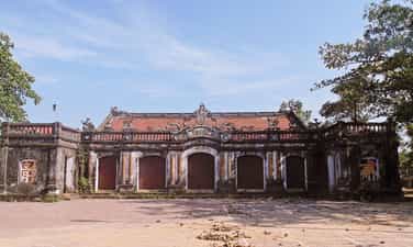
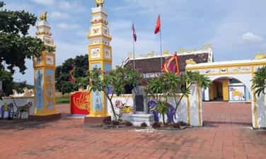
Hoa Ninh Communal House.
Hoa Ninh Communal House belongs to Hoa Ninh village, formerly Quang Hoa commune, Ba Don town, built in the 11th year of Bao Dai - 1936. During feudal times, the communal house was both a "communication station for army corps to serve administrative purposes." army", is also a place to worship heroes, those who openly reclaimed wasteland to establish villages... Along with cultural values, Hoa Ninh communal house during the two resistance wars against the French and the American invasion was also a place that marked many historical events. The communal house was a meeting place for the people, where rallies of the Viet Minh front took place calling for the masses to rise up to seize power in villages and district capitals (August 1945). During the years of resistance against America to save the country, this was also the place where our armed forces gathered and was a warehouse to hide weapons ready to fight back against enemy aircraft when they attacked the North. In 1965, American enemy bombs severely damaged Hoa Ninh communal house. But, with the determination of the people and the close guidance of the authorities at all levels, in 1976, the communal house was successfully renovated and became a "golden address" for the next generation to enhance their self-esteem. pride and responsibility for the glorious tradition of our ancestors. In 1993, the (former) Ministry of Culture and Information ranked Hoa Ninh Communal House as a national historical and cultural relic. Hoa Ninh Communal House was built with a massive and meticulous scale and architecture. The communal house is arranged with a system of surrounding walls, pillar gates, screens and a horizontal grand communal house. The sharpness and sophistication are shown right at the gate of the communal house, with the main gate built of bricks. The two pillars on both sides are designed extremely elaborately, the lines are in harmony with each motif and color. On the tops of the two pillars are images of two pigs delicately covered with green and light brown enamel, showing the strength of solidarity of the people. The communal house gate bears bold architectural and artistic features of Vietnamese villages. Hoa Ninh communal house in Quang Hoa commune consists of 5 rooms, 4 rooms, 1 main door and 4 side doors. In front of the main door of the communal house, there is an engraving of the word "Tho" embedded in the moon and three embossed Chinese characters: Phuc, Du, Dong. This is also the center for displaying decorative motifs such as: Dragon, Lion, Turtle, Phung, precious bowls, flowers... by the art of plastering and assembling pieces of porcelain and porcelain. In addition, this area also has 2 more couplets by bachelor Nguyen Tien Ich. Hoa Ninh communal house has a unique roof, built in a quadrilateral style, two upper roofs in the front and back, two lower roofs at the East and West ends. In the middle of the communal house's roof is the sacred image of two dragons flanking the moon. Every year, on every occasion of Tet, at Hoa Ninh communal house in Quang Binh, there is a Ky Phuc festival, this is a festival with the purpose of praying for blessings for the people, praying for peace in the country and people, good harvests, and smooth sailing. wind... In addition to the meaning of praying for good fortune, this is also an occasion for the people of Quang Hoa village, and more importantly, the people of Quang Binh, to remember their ancestors and preserve their national cultural identity. Source Electronic information portal of Quang Hoa commune, Ba Don town, Quang Binh province.
Quang Tri
3595 view
Rating : National monument.

Tan So Citadel Ruins
Tan So Thanh Base Relic is located in Mai Dan village, Cam Chinh commune, Cam Lo district. Tan So Citadel Base Relic was ranked National by the Ministry of Culture and Information on January 16, 1995. This is a relic of the last military citadel of the feudal dynasty of the Nguyen Dynasty marking historical events. Important history of the Can Vuong movement against the French in the early 20th century. Tan So is a land isolated from the plain and far away from the center of the provincial capitals. Surrounded on all four sides are mountain peaks and natural hills created like a closed citadel. The east side faces the Trieu - Hai plain, which is very convenient for communication with the lowlands. On the other sides, there are roads leading through Laos and to the North in case of retreat, so this place has been chosen by the feudal monarchy through the ages as a border guard post and mountain guard station. In 1883, it changed to Quang Tri Son Phong, also known as Tan So citadel. The resistance base in Tan So began construction in 1883 and was completed in 1885. Under the direction of mandarins: Nguyen Van Tuong, Ton That Le, Dang Duy Cat, thousands of soldiers and villagers worked diligently day and night. It was from the work of digging soil and planting bamboo to build the Tan So base that took a lot of effort, but our people did not think about their own benefits and had a song: "Eat home and carry bamboo and ivory for the mandarins." . Tan So citadel has a rectangular structure: length 548m, width 418m, total area is 22.9 hectares. The outer citadel has 4 gates: Front, Back, Left, Right covered with soil, outside there is a fence with sharp stakes and a surrounding moat system (2m deep, 10m wide), 4 sides of the wall are densely planted with ivory bamboo in four layers. Dozens of meters apart, between layers of bamboo is a wall made of soil. The 4 corners of the citadel have 4 wells 20m deep. Inside the outer citadel there are houses, barracks, warehouses, and training grounds for elephants and horses; At the gates and corners of the citadel, there are military posts and gun emplacements to guard and protect the inner citadel. The inner citadel was built of solid bricks, length is 165 m, width 100m, total area is 1.65 hectares. The inner city has 5 gates: Tien, Hau, Left, Right and Ngo Mon for the king and mandarins to enter and exit the palace. Inside the citadel, there are buildings where officials live and work. The French colonialists, after being attacked by the Nguyen Dynasty's imperial army, took brutal revenge. They caused a brutal massacre of the people of Hue capital, then immediately invaded Tan So, capturing King Ham Nghi and the leaders of the militant faction. In the end, the French captured Tan So, they burned it down and completely destroyed it. Tan So was engulfed in flames, signaling the end of a capital city - a nerve center leading the Can Vuong movement, recording an extremely heroic historical milestone against foreign invaders of our nation, becoming the place where witnessed and recorded the national spirit of a patriotic king - King Ham Nghi. After peace, Tan So was littered with piles of war scrap and filled with hundreds of bomb craters. The Tan So Citadel Base relic is in dire need of preservation and restoration. Source: Quang Tri Newspaper
Quang Tri
4674 view
Rating : National monument
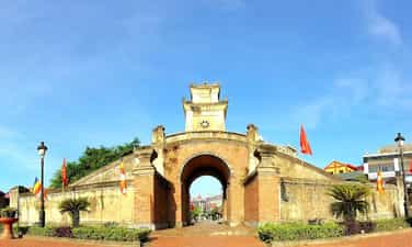
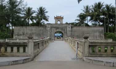
Quang Binh Quan
Quang Binh Quan (newly restored), right in the center of Dong Hai ward between four roads: the west is the road to Duc Ninh, the east is Me Suot road down to Nhat Le river wharf, the north is the road to Hanoi Noi, the south is the road to Hue. Quang Binh Quan also has many names. Some people say it is the entrance to Quang Binh palace, others say Binh Quan Gate. The book Dai Nam Nhat Thong Chi records: ''The mandarin gate is two truong 1 meter long, two truong 5 meters wide; The outer citadel protecting the mandarin gate is 14 meters long, 6 meters high, 3 meters high, built in the year of Minh Menh (1826) with brick and stone...'' Quang Binh Quan under the Nguyen Dynasty, covered with soil in 1631, is an ancient rampart system built to protect the Nguyen citadel. Quang Binh Quan is located in the Luy Thay system, including Luy Truong Duc, Luy Tran Ninh, Luy Nhat Le, Luy Truong Sa, stretching more than 30 km. The Luy Thay system was designed and directly directed by Lord Nguyen's military advisor Dao Duy Tu (1572-1634) and directly directed its construction from 1631-1634, to help Lord Nguyen in Dang Trong fight against attacks by Lord Trinh in Dang Ngoai during the Trinh - Nguyen period was divided. This place has a mountain-like terrain near a very solid ravine, separated from the North, extremely dangerous, like going into Thuc land. During the reign of Lord Nguyen, if people from Southern Bo Chinh or from the North had any business, if they wanted to go to Quang Binh palace, if they went by road, they had to first go to Quang Binh Quan to present their documents and then go back to the north and enter Nam Mon gate to leave. castle. Those traveling by water must stop by the boat at Nhat Le gate, present documents at Thu Ngu mandarin gate, then take the boat to the east gate to enter the citadel. Quang Binh Quan is located guarding the North-South vital road and waterway from Nhat Le seaport. Therefore, more than 7 times Lord Trinh's army crossed the Gianh River to the South and were stopped here. As painful evidence of a time of national conflict, Quang Binh Quan as well as the Luy Thay system have shown the high development of the architectural art of Vietnamese military fortifications. This place is the center of the Luy Thay rampart system, Quang Binh Quan was built according to a unique architectural model, harmoniously combining two elements, both a solid and solid defensive battle rampart, and a a unique architectural work of art. Quang Binh Quan is a reliable address for future architectural and military researchers. In 1825, King Minh Mang restored Quang Binh Quan and raised the watchtower with solid baked bricks. After inauguration, the king classified Quang Binh Quan as one of the special historical and cultural works. of the country, having the image of Quang Binh Quan embossed in Nghi Dinh placed in front of The Mieu Temple in the Forbidden City. Before the August Revolution of 1945, Quang Binh Quan (on Duc Ninh Street) also had a moat outside the citadel, a brick bridge around the moat and at the intersection between Duc Ninh and Cau Rao streets (in the past, during the Nguyen Lord's time, it was the There is also a ghost in a large cemetery. Quang Binh Quan was destroyed by the French army when they withdrew from Dong Hoi in 1954, then rebuilt almost identically. In 1965, the war broke out and was destroyed by American aircraft. Currently, Quang Binh Quan has been restored to its original appearance more than three centuries ago. Quang Binh Quan, an architectural relic with historical and artistic value, is a typical cultural symbol of the land of outstanding people. Source: QUANG BINH GENERAL MUSEUM
Quang Tri
4141 view
Rating : National monument

Cau Nhi communal house
Cau Nhi communal house relic belongs to Cau Nhi village, Hai Tan commune, Hai Lang district (now Hai Phong commune, Hai Lang district), a place associated with famous man Bui Duc Tai. The relic was ranked nationally by the Ministry of Culture and Information on March 13, 2001. Cau Nhi village in Hai Tan commune was formerly called Cau Lam - a village famous for literature. This land has produced many famous figures at one time, among them the famous Bui Duc Tai. Existing documents indicate that the village was founded in the early 15th century. Cau Nhi communal house was originally a large and beautiful communal house famous throughout the region. According to Thi Thien, the first communal house was built in the land that is now also called communal house in the early years of the early Le dynasty (1428 - 1433). During the Tay Son period, the communal house was moved to the beginning of the village, on the edge of the river confluence - at the current location. The Bui family genealogy shows that the communal house was built in 1879 and completed in 1882. This is the first time a large-scale communal house was built. The architecture of the communal house is a large house with 5 rooms and 2 wings. The wooden frame has a sturdy structure, the main columns are made of ironwood, the other columns are made of jackfruit wood. The roof is tiled. Surrounding the communal house is a brick wall covering three sides. In 1950, during the French invasion, the communal house was completely burned down. In 1955, the village organized a fundraising campaign to renovate, but due to lack of material resources, the area of the communal house had to be narrowed and the architectural appearance also changed. These are two horizontal rows of houses in the style of a second letter, made in the style of a 3-compartment, 2-wing house. In front is the front hall, behind is the main hall. During the war against America, Cau Nhi communal house, like many other communal houses in Quang Tri, could not avoid being destroyed by bombs and bullets. Cau Nhi Communal House was restored three times in 1967, 1985 and 1955. In 1991, the screen and front gate were rebuilt. The communal house currently only consists of a 3-room house, small in scale, spread horizontally, facing the O Lau river. The two gables are built with flat walls, the three sides are built with brick walls, the front is installed with a "upper but lower" door system. Structure of several stacks and roof columns. The roof is covered with hooked tiles. Although the dragon motifs on the roof are not monotonous, they are nothing special. The screen and city gate were rebuilt on a very large scale. In the communal house area, there is a notable architectural work, Van Thanh, located in the northwest corner, which villagers built to worship Confucius and those who passed the exam in order to hope that future descendants will follow the saint's lineage. In front of the communal house is a village market that opens every morning. It still exists today but is not very crowded. Behind the village communal house, across the road is Quan Kho pagoda. In the precincts of the pagoda, there was formerly a shrine worshiping Minister of Rites Bui Duc Tai (now only the foundation remains). Inside, the tutelary god and those who contributed to building the communal house are worshiped. The festival is held every year at Cau Nhi village communal house with the Cau An ceremony held on the first days of the year; On ceremonial occasions, villagers often organize village festivals with performances and fun games such as boat racing, fairs, swings, chess games... During its history, Cau Nhi communal house was the place where many events related to Cau Nhi village and Hai Lang land in Quang Tri took place. Under the Mac dynasty (1527 - 1592), the people of Cau Nhi, led by local general Hoang Boi, used the village communal house as a meeting place, practiced martial arts, and stored food. The Hoang Boi uprising left historical marks on the land on the banks of the O Lau River. During the resistance war against the French invasion, Cau Nhi communal house was the headquarters of the Hai Tan Commune Resistance Administrative Committee - where for the first time people on the banks of the O Lau River were able to hold ballots to elect the 1st National Assembly of Vietnam. Democratic Republic as the people's rule. This is also the place to organize meetings, practice self-defense, carry out movements to eliminate hunger, ignorance, golden week... Source: Historical and cultural relics and scenic spots in Quang Tri province
Quang Tri
6410 view
Rating : National monument

Memorial House of General Secretary Le Duan
General Secretary Le Duan's memorial area is located on the banks of Thach Han River, in Hau Kien village, Trieu Thanh commune, Trieu Phong district, Quang Tri province. The memorial relic area of General Secretary Le Duan was recognized as a national relic on October 29, 2010. Le Duan (1907 - 1986) was a son of Bich La Dong village, Trieu Dong commune, Trieu Phong district, Quang Tri province. Born and raised in a land with a rich patriotic tradition, Le Duan soon became enlightened about the revolution. In 1928, he joined the Vietnam Revolutionary Youth Association and became one of the first class members of the Communist Party of Vietnam. A life of vibrant revolutionary activities is closely linked to the history of revolutionary struggle as well as the cause of national liberation and building Socialism of the Party and country. During 26 years, as First Secretary and then General Secretary, no matter what the circumstances, comrade Le Duan always upheld the steadfast spirit of communists, especially those who contributed to it. Your great contribution to the revolutionary cause of national liberation, national reunification, and bringing the whole country forward to build socialism initiated and led by the Communist Party of Vietnam. Le Duan deserves to be an outstanding leader of the nation, a steadfast soldier of the international Communist and workers' movements and an outstanding son of his homeland Quang Tri. "Relics of General Secretary Le Duan's memorial area", is the common name for a complex of relics including: Comrade Le Duan's memorial house - the living place of comrade's family since moving from Bich La Dong to Hau Kien is now a place to worship two of his parents and comrades in his hometown, Hau Kien village; The memorial house is a place to hold ceremonies and visit visitors; The additional gallery is a place to display artifacts and photos related to comrade Le Duan's life and career. The memorial house of late General Secretary Le Duan is located on an area of 2,000 square meters. Formerly the house and garden of Le Hiep's father. The house is made of wood, quite spacious. Through two brutal wars, the house was burned many times, and after liberation, only the floor remained. In 1976, to show respect and gratitude for his great contributions to the Party and State, the Party Committee and people of Trieu Phong district joined hands to help rebuild his family's house on the ground. old. The house is structured in the form of an old bank, consisting of 3 rooms and 2 wings, with a back house (lower house) 4.5m wide, 9m long, thatched roof, bamboo walls, plastered with mud and wood. Inside the house, furniture such as beds, beds, tables, altar cabinets, etc. were restored. At the end of 1977, the thatched roof was damaged and the District People's Committee replaced it with moldy tiles. From 1978 - 1985, it continued to undergo many repairs and renovations, replacing bamboo walls with pressed wood. In 1995, the Quang Tri Provincial Museum restored the house based on the structure of the old house (four or two wings, with a back house) 10m wide, 12m long, each room 2.5m wide, each wing 1m wide. .5m with awning. In 2005, the planning, construction, restoration and embellishment of the memorial site of General Secretary Le Duan was completed, and a number of artifacts and documents previously displayed in the memorial house were transferred to display at the Exhibition House. additional. The memorial house is still used as a place to worship his parents and comrade Le Duan. The memorial relic area of General Secretary Le Duan is a historical relic commemorating typical famous people of Quang Tri province, linking the youth and years of revolutionary activities of the comrade in his hometown with the existence and developing the revolutionary struggle movement of the Party Committee and people of Quang Tri in the two resistance wars against French colonialism and American imperialism. Source: Quang Tri Provincial Museum and Monument Management Center
Quang Tri
7532 view
Rating : National monument

Vinh Moc Tunnels
Vinh Moc Tunnels and Vinh Linh Tunnel Village System are magnificent underground military structures, born during the resistance war against the US to save the country. With the slogan "militarize the entire population, fortification of the entire region" Vinh Linh's army and people have dug trenches, with many functions: headquarters, logistics warehouses, schools, hospitals, living areas. of each family..., arranged throughout the residential areas, along the roads, along the fields, and on the coast, connected by a network of trenches instead of roads on the ground. From the end of 1965 to 1968 (according to incomplete statistics), the entire Vinh Linh district had 114 tunnels with a total length of more than 40km, a trench system of more than 2,000km and hundreds of other tunnels, which became "tunnel village" - appeared for the first time in the history of the Vietnam War, expressing the will to "not move one inch, not leave one inch" to stay and fight to protect the homeland and keep blood vessels open to the front line. Vinh Moc Tunnels and Vinh Linh tunnel village system are distributed throughout 15 communes and towns of Vinh Linh district, Quang Tri province, including: 1. Vinh Moc Tunnel (Vinh Thach). Belongs to Vinh Moc village and Son Ha village, Vinh Thach commune. Includes 13 doors (6 doors open to the hill, 7 doors open to the sea). Along both sides of the tunnel, there are small niches enough for 2 to 4 people. In the basement there is also a hall (capacity of 50 to 60 people), a place for meetings, watching movies, performing arts... and a number of other works such as: bulletin board, maternity home, 3 water wells, toilet, surgery station, infirmary, cooking kitchen (Hoang Cam kitchen). In addition to the underground tunnel and tunnel system, Vinh Moc Tunnels also has above ground works such as trenches, artillery emplacements, breakwaters, exhibition houses... 2. Hien Dung tunnel system (Vinh Hoa). Located in Hien Dung village, Vinh Hoa commune, including 2 tunnels: The tunnel of the People's Armed Police Command in Vinh Linh area is about 1,540m long, including 18 up and down doors and 15 ventilation wells. The People's Armed Police Information Tunnel in Vinh Linh area has 8 up and down doors and 10 ventilation wells. 3. Huong Nam tunnel system, Troong Mon - Cua Hang, Rooc village and Hai Quan tunnels (Vinh Kim). Including Huong Nam Tunnel: belongs to Huong Nam village, Vinh Kim commune. Troong Mon tunnel system: located close to the coast of Vinh Kim commune. Cua Hang Tunnel: The tunnel axis runs East - West, with 2 doors. Rooc village tunnel: belongs to Rooc village Naval Tunnels: These tunnels are located close to each other within a radius of 50m including: Naval Tunnel 1, Naval Tunnel 2, Naval Tunnel 3, Naval Tunnel 4. 4. Mui Si tunnel system, tunnel 61 (Cua Tung town). Including Mui Si Tunnel: located on the coastal road from Cua Tung to Vinh Moc Tunnel, in Thach Ban neighborhood, Cua Tung town. Tunnel 61: located on the road leading to Ben village, An Hoa 2 neighborhood, Cua Tung town. 5. Naval Tunnels (Vinh Nam). Located on a hill in Nam Cuong village, Vinh Nam commune. Vinh Moc Tunnels and the Vinh Linh underground village system are historical evidence of strength, indomitable spirit, the unyielding will to hold on to the land to defend the village, the unique creativity of the people's war, and a shining symbol of revolutionary heroism, greatly contributing to the victory of the resistance war against America to save our nation. With particularly typical values, the historical relics of Vinh Moc Tunnels and Vinh Linh Tunnel Village System (Vinh Linh district, Quang Tri province) have been ranked as special national relics. Source: Department of Cultural Heritage
Quang Tri
7639 view
Rating : Special national monument
DOC MIEU MILITARY BASE
Doc Mieu military base is located in Gio Phong commune, Gio Linh district, Quang Tri province. This historical site is quite famous and is considered an "impregnable fortress" during the resistance war against the French colonialists and American imperialists. Located east of National Highway 1A, about 7km south of Hien Luong Bridge, Doc Mieu is a basalt hill located in a terrain area consisting of three zigzag slopes. This is also the defense line built by the US called Namara - the name of a general commanding the US - Puppet army, to prevent all reinforcements from the North and the Southern battlefield. Among them, Doc Mieu military base is the most important base in this line. Here, the enemy built a system of vaulted tunnels and mobile blockhouses made of concrete. Along with that is an artillery battle towards the north bank of the Ben Hai River, a control center to protect the fence, an armored patrol squad, and many American and puppet companies deployed. Surrounding the base are barbed wire fences with 12 layers of 3m high, on top is a fence with automatic mines, under the fence is a dense minefield hundreds of meters wide. In 1972, our army and people simultaneously opened fire, fired DKD grenades, A12 grenades, and rocket launchers, surrounding the Doc Mieu military base. After three consecutive days of attacks, the enemy had to flee on the night of March 31, 1972, leaving behind their posts, associates, and modern electronic fence system. Currently, our government built a victory monument to recognize the soldiers who fought heroically. At the foot are long, straight rubber hills, proof of the vibrant revival of life in this once-torn land. Doc Mieu military base relic has become a historical tourist attraction for tourists to visit every time they come to Quang Tri. This is not only a symbol of our nation's indomitable fighting spirit but also has profound educational significance for the country's future generations. Source: Quang Tri Newspaper
Quang Tri
7979 view
Rating : National monument

Truong Son National Martyrs Cemetery
Truong Son Martyrs Cemetery is located on Ben Tat hill, next to National Highway 15, in Vinh Truong commune, Gio Linh district; about 38km northwest of the provincial center (Dong Ha town); about 20km northwest of National Highway 1A (in Gio Linh district town). After the day of national reunification, the Party Central Committee and the Ministry of National Defense approved the project to build the Truong Son martyrs cemetery in Quang Tri province as a place to commemorate and honor the beloved children of the heroic homeland. Bravely sacrificed his blood on the Truong Son roads for the cause of national liberation. Construction of the cemetery began on October 24, 1975 and was completed on April 10, 1977. The construction commander is the 559th Division Command with the participation of more than 40 main army units and local soldiers. There is also a group of workers specializing in engraving words on stone stele in Hoa Hai commune, Hoa Vang district, Quang Nam province. Truong Son Martyrs Cemetery is where 10,333 graves of martyrs gather; has a total area of 140,000m2; Of which, the grave area is 23,000m2, the monument area is 7,000m2, the green tree planting area is 60,000m2, the lake area is 35,000m2 and the paved road network within the cemetery grounds is 15,000m2. The grave plot is divided into 10 main areas. Truong Son Martyrs Cemetery is the eternal resting place of the soldiers who sacrificed their lives on the Ho Chi Minh Trail during the anti-American era to save the country. This is the most massive, largest-scale, highly artistic gratitude project, expressing the deep remembrance, gratitude and secret honor of the entire Party, the entire army and the entire people of our country. with our beloved children in all parts of the country who spared no blood for the cause of the struggle to liberate and unify the country. On the occasion of the 40th anniversary of the founding of the Truong Son army (May 19, 1959 - May 19, 1999), the Party and State decided to upgrade and renovate Truong Son cemetery including many items: Entrance gate to Truong Son cemetery, road system and surrounding wall, command post model, local symbols, statue clusters, drainage system, internal electricity, planting trees around the cemetery and houses celebration, Fatherland Radio recognized... Up to now all items of the project have basically been completed. Truong Son Martyrs Cemetery today is not only the resting place of heroic martyrs but also a place of worship, a shining symbol of revolutionary heroism, of the spirit and will to fight for independence. independence and the desire for peace of our people. Truong Son Martyrs Cemetery is not only a place for martyrs' families, Party and State delegations, and local governments to visit and perform gratitude work, but also a place of pilgrimage. of people all over the country and international friends following the noble moral tradition of the Vietnamese people: when drinking water, remember its source. Currently, Truong Son Martyrs Cemetery has 24 officers and employees who regularly take care of, repair and welcome martyrs' families and domestic and foreign delegations to visit. Source: Office of the People's Committee of Quang Tri Province
Quang Tri
7732 view
Rating : Special national monument

Ta Con Airport
Ta Con airport relic area is located in Hoa Thanh village, Tan Hop commune, Huong Hoa district, Quang Tri province. With a terrain like a valley surrounded by hills and mountains, Ta Con airport was one of the strategic military bases of the US army in the years 1966 - 1968 at the Khe Sanh battlefield. Near the border, located on National Highway 9 connecting Dong Ha (Vietnam with Southern Laos), this place has an important military strategic position not only on the Quang Tri battlefield but also in the Indochina region. That's why Khe Sanh was used by the US military as a springboard for ground operations. Ta Con Airport was built with the purpose of allowing reconnaissance aircraft to check and point out many raiding, blocking and cutting off Ho Chi Minh routes. In particular, located in the Namara electronic fence system stretching from Cua Tung beach to the border area, Khe Sanh base is determined to be the center. Therefore, the US military built the most solid defense group in the US in the southern region of Vietnam, including bases: Lang Vay, Huong Hoa Military Branch - a cluster of defensive bases at Ta Con airport. . And the Ta Con stronghold cluster - Ta Con airport, is considered a construction center with a scale of 2km long, 1km wide, including many sub-bases with dense fortifications and a large airport. The airport has an area of about 10,000 square meters located in the middle of the base with a runway paved with thousands of tons of aluminum and iron rims. This place became the take-off and landing place for armed helicopters, combat jets and even heavy military transport aircraft such as C130 and C123. In the airport area, there is a base command headquarters, an airport command post, a communication station... and a dense system of defensive fortifications. Outside is a loose wire fence and large minefields. Along with modern military equipment and an important location, Ta Con airport and adjacent high points formed a continuous, mobile defense position, considered by the US and puppet troops at that time to be the most important. the most "hard" position in the entire Khe Sanh base group system. And Ta Con airport is considered by the US military as an invincible fortress Here, faced with the power of the Vietnam People's Army's attacks to liberate Khe Sanh from February to July 1968, the US military had no choice but to launch a tactical withdrawal by air force to saved thousands of American soldiers. Exactly 55 years ago, on July 9, 1968, our army's victory flag flew over Ta Con airport base. The Route 9-Khe Sanh campaign ended with a resounding victory. Khe Sanh - Huong Hoa was the first district of Quang Tri and the South to be completely liberated and created firm confidence for our army and people to advance to complete victory, liberate the South, and unify the country. At the current Ta Con airport relic site, the Museum of Street 9 - Khe Sanh is a place to display hundreds of valuable historical and scientific artifacts. Along with that, the tunnel system, air traffic observation tower... were restored within the airport campus. In 1986, Ta Con airport relics were ranked as national relics. This place also displays outdoor artifacts such as airplanes, tanks, artillery and dozens of bomb and bullet casings. These are the weapons and means of war that the US military used to fight at the Khe Sanh - Ta Con battlefield 55 years ago. Source: Ministry of Culture, Sports and Tourism
Quang Tri
4950 view
Rating : National monument

Lao Bao Prison
Lao Bao Prison Relics, also known as Lao Bao Exile House, is located southwest of Road 9, next to the Se Pon River, in Duy Tan village, Lao Bao town; The monument was ranked National on January 25, 1991. During the feudal period, Lao Bao was a border post of the Nguyen Dynasty, used to guard a part of the western border of the country, and also used as a place to exile criminals with heavy sentences. Since the French colonialists placed protectorate over Vietnam and officially opened Route 9 (in 1904), after 4 years, the colonial government began upgrading Bao Tran Lao during the Nguyen Dynasty into a Lao prison. Bao (1908). When first established, Lao Bao prison had only two rows of wooden cells, tiled roofs, and plastered walls, called Lao A and Lao B; Each row of buildings is 15m long, 5m wide, 2m high and can hold 60 prisoners. Since the birth of the Communist Party of Vietnam, many revolutionary movements broke out throughout the Central region, and the French colonialists increased their hunting, arrests, and suppression of the revolution. To serve the detention of prisoners who are members of the Communist Party. At the end of 1934, they built an additional system of solid prisons made of concrete and reinforced steel, prisons C, D, cellar E; Each prison is 30m long and 6m wide. Detain about 180 prisoners. And the solitary confinement area has 13 rooms, each room is 1m wide, 2.14m high. All buildings are surrounded by a 3.5m high solid wall system and many protective bunkers at the corners and walls. important position. In addition, there are a number of other service works such as: the Commander's House, torture and interrogation house, barracks, warehouse, carpentry workshop, blacksmith workshop... These works are located on an area of more than 10 hectares. Lao Bao Prison is one of the five largest prisons in Indochina, imprisoning patriots and communist soldiers of the Central region. With the harsh climate, wild mosquitoes, flash floods, and harsh prison regimes such as brutal torture and heavy forced labor; Bad food, illness and no medicine have tortured people's bodies to death... Lao Bao prison has become a living hell for prisoners. For nearly 40 years of existence, Lao Bao prison has imprisoned thousands of Communist soldiers and patriots. Through two wars, especially during the war against the US, Lao Bao Prison was almost completely destroyed, many buildings only had part of their architecture remaining such as: Lao C, D, E, Question House. palace, solitary confinement area, some bunkers... but most have been deformed and become abandoned. Today, in addition to the evidence of the crimes committed by the enemy against our nation, there are also a number of new constructions built here to serve the work of preserving and promoting the value of relics such as: Additional displays, Monument cluster, Stele house, Reception house... Lao Bao Prison is living evidence of the crimes of the French colonialists against our people in the first decades of the 20th century. Source: Quang Tri Newspaper
Quang Tri
4641 view
Rating : National monument

The banks of Hien Luong - Ben Hai
The Hien Luong - Ben Hai Banks Relic is located in Vinh Linh district (Vinh Thanh, Vinh Giang, Vinh Son communes, Cua Tung town) and Gio Linh district (Trung Hai commune), Quang Tri province. Hien Luong - Ben Hai is a place that witnessed the pain of division between the two regions and historical events associated with the process of fighting for national liberation and unification of our army and people during the anti-American period - Wei. After the Geneva Accords were signed (July 20, 1954), our country was temporarily divided into two regions, North and South, taking the 17th parallel (Ben Hai River) as the boundary, waiting until October. In July 1956, general elections were held to unify the country. But with the events caused by the sabotage of hostile forces, it took us 21 years (1975), with the blood of soldiers and compatriots, to gain independence and unity. country. The main axis of this monument lies in the North - South direction, with the center being the historic Hien Luong Bridge - the span connecting the Northern Flagpole and the "Aspiration for Unification" monument cluster on the Southern bank. The main components of the monument include: 1. Area on both banks of Hien Luong bridge: Including the following relics: Hien Luong Bridge, Union House, Hien Luong flagpole, North bank loudspeaker system, Hien Luong Police Station, "Latitude" exhibition house 17 and the desire for unity", South Coast Police Station, Monument Cluster "The Desire for Unity". 2. Cua Tung Police Station. Currently, the Cua Tung Police Station location belongs to Border Guard Station 204 barracks. In addition to the function of working and staying, the project also serves national security purposes. The lower floor of the two-story building is partly reserved for the Station's Traditional House, displaying 92 documentary photos and 60 artifacts directly related to the history of the revolutionary struggle of officers and soldiers of Cua Police Station. Tung, posts and stations along the North bank of Ben Hai River and Border Guard Station 204 since 1954. 3. Ferry wharves on Hien Luong River - Ben Hai: Including the following relics: Cua Tung wharf (Ferry A), Tung Luat wharf (Ferry B), Luy wharf (Ferry C), Wharf Thuong Dong and Duc Duc boats. 4. The monument includes: a pedestal and a symbolic artistic complex, with the image of boats rushing forward, despite all dangers and enemy bombs, bringing goods and equipment at night. team entered the battlefield to fight the Americans. In addition to preserving and embellishing relics, the Unification Festival is periodically held at the relic on April 30 every year (normal years are organized by the locality, even years are organized by the Ministry of Culture and Sports). and Tourism and the People's Committee of Quang Tri province co-organised). This is a unique revolutionary festival, unique to the Hien Luong - Ben Hai banks relic site, Quang Tri. With the special values of the relic, on December 9, 2013, the Prime Minister ranked the Hien Luong - Ben Hai banks historical relic (Vinh Linh district and Gio Linh district, Quang Tri province) as a relic. special national monument. Source: Department of Cultural Heritage
Quang Tri
4525 view
Rating : Special national monument
Quang Tri ancient citadel
Quang Tri Ancient Citadel relic is located in the heart of Quang Tri town; nearly 1km northeast of National Highway 1A, about 14km southeast of Dong Ha city - the capital of Quang Tri province today. Quang Tri Ancient Citadel was built during the reign of King Gia Long and was completed during the reign of King Minh Mang, lasting nearly 28 years (1809-1837). The citadel was initially covered with soil, and in 1837, King Minh Mang rebuilt it. with bricks. The citadel's campus has a square shape with a wall circumference of 2160m long, the citadel is 3m high, 13.5m thick at the base, and 0.72m thick at the top. Outside the citadel, there is a wide moat system surrounding it. The four corners of the citadel are four high fortresses jutting out. The citadel has 4 gates: Front, Back, Left, Right. Built with a rolling arch, 3.4m wide, above is a gazebo, curved roof, tiled, all 4 gates are located in the middle of the 4 sides of the Citadel. During the period of French colonial domination, Quang Tri Citadel served as the nerve center of the local and provincial governance apparatus. Quang Tri Ancient Citadel was chosen by the French army as one of the important bases of the military station system. France built an additional prison system, expanded and solidified the prison to serve as a place to detain patriots and revolutionary soldiers in the province and region. Quang Tri Prison at one time became the center of leadership of the revolutionary movement because this was the place where the core core of youth, the first communist soldiers of Quang Tri and many leaders of the Communist Party of Vietnam were detained. The Provincial Party Committee and the Regional Party Committee belonged to the pre-uprising period. Coming to the American - puppet period. After the Geneva Agreement was signed on July 20, 1954, according to the agreement, the 17th parallel was used as the temporary dividing line. A part of Quang Tri from Ben Hai River outward was liberated, the districts from Gio Linh back to Hai Lang became a new type of colony of the American empire. Quang Tri Town, including Quang Tri Ancient Citadel, became the political, military, economic and social center. The US - puppet transformed the Citadel into a military zone, used it as a military warehouse and command center for the entire province, and opened more prisons to suppress the revolutionary movement. The 1972 strategic offensive across the South began. On April 28, we captured Dong Ha and approached Quang Tri town. On May 2, Quang Tri Town was liberated. The victory of the Quang Tri campaign in 1972 fundamentally changed the battlefield situation, pushing the US strategy of "Vietnamization of the war" to the brink of bankruptcy, creating momentum and room for the complete liberation of the South. . Having lost Quang Tri, the US-puppet crazily launched a counterattack to recapture Quang Tri with the code name "Lam Son 72". The number 1 goal is to capture Quang Tri Ancient Citadel. Quang Tri town during the 81 days and nights from June 28 to September 16 was likened to a bag of bombs. On average, every day the enemy mobilized jet planes 150-170 times and B52s 70-90 times to bomb and destroy the town and Quang Tri Ancient Citadel. With an area of less than 3 kilometers, in 81 days and nights, the town and Quang Tri Ancient Citadel had to bear 328,000 tons of bombs and bullets, on average each of our soldiers had to bear 100 tons of bombs and 200 artillery shells. We were determined to keep the city, while the enemy tried to capture the city at all costs. Thousands of soldiers sacrificed their lives here, but their remains have not yet been retrieved because there was too much smoke, fire, and bombs. Their blood and bones have mixed into the rubble and rubble. That's why today at the center of the monument, people built a memorial to form a common grave for thousands of soldiers who fell during these fierce days and nights. This mass grave was designed according to the concept of yin and yang philosophy, which has a profound meaning to escape the souls of the deceased. There are 81 stairs going up, symbolizing 81 days and nights of fighting in Quang Tri ancient citadel. Source: Quang Tri Provincial Museum and Monument Management Center
Quang Tri
5115 view
Rating : Special national monument
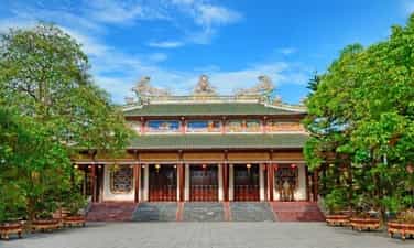
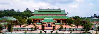
Sac Tu Tinh Quang Pagoda
Sac Tu Pagoda is located on the hills southwest of Ai Tu village in Ai Tu town, Trieu Phong district, Quang Tri province. The pagoda belongs to the Northern Buddhist sect. Sac Tu Tinh Quang Pagoda was originally named Am Tinh Do, built in the early years of the Le Dynasty (1735 - 1739). In the 5th year of Ky Suu, Vinh Huu (1739, reign of King Le Y Tong), Lord Nguyen Phuc Khoat (Vuong Vo) on one occasion went to Quang Tri and was impressed with the scenery of the Buddhist hall and the temple's reputation among the people. So he used his pen to write the five words "Sac Tu Tinh Quang Tu" and then had the plaque made with red lacquer and gilded to give it to the pagoda. From then on, Tinh Do Am was changed to Tinh Quang Pagoda and people from then on became accustomed to calling the pagoda by the name Sac Tu Pagoda (the pagoda ordained by the state), while the Buddhists used to use the combination: Sac Tu Tinh Quang Pagoda. . The pagoda's structure includes a traditional beam house with a match-stacked roof, the main materials used are cement and reinforced steel with a total area of 837m2. The roof is elaborately decorated with stucco art and porcelain pieces. The roof of the pagoda is straight and decorated with dragon patterns. In the temple grounds, there is a Bodhisattva Avalokiteśvara monument (built in 1976) and a number of towers that are the tombs of deceased abbots. The three-entrance gate is built with two roof floors, the upper floor is decorated with a statue of the Dharma Protector facing the pagoda. Behind the three gates, there is a bridge over the lotus pond to enter the front yard of the pagoda and the main hall. The main hall is 31m deep, 27m wide, nearly 15m high, has a match-stacked roof architecture, and the roof is decorated with four sacred animals; On the front, between the two roofs, there are 5 bas-reliefs about the Buddha's life: Birth, renunciation, enlightenment, sermon and nirvana. The main hall of Sac Tu pagoda is in the middle space, the upper class worships the statue of Tam The, next is Shakyamuni meditating with on the left and right are Anan Da and Ca Diep standing. The outermost is Maitreya, the newborn Shakyamuni. The left side worships the statue of Avalokiteśvara Bodhisattva. In front there is a statue of Samantabhadra Bodhisattva sitting on a unicorn. Friends worship the statue of Ksitigarbha Bodhisattva, in front is the statue of Manjushri Bodhisattva riding a dragon horse. The back of the hall worships the statue of Bodhidharma, Patriarch Chi Kha - the founder of Sac Tu Pagoda and two monks, Tuyet Phong and Buu Ngan - who belong to the first generation of abbots at the pagoda. The pagoda has a bronze statue of Shakyamuni Buddha weighing 2,700 kg, cast in 1997, and a large drum made of buffalo leather, with a diameter of 165 cm. In the temple grounds there is a Bodhisattva Avalokiteśvara station. Sac Tu Tinh Quang Pagoda is a famous ancestral temple of Buddhism in Dang Trong, a place where many famous and virtuous monks have been nurtured and trained. The annual death anniversary festival on the 18th day of the second lunar month is held on a large scale with the participation of thousands of monks, nuns, Buddhists in Quang Tri, neighboring provinces and pilgrims everywhere. On November 15, 1991, the pagoda was ranked as a national historical-cultural relic. Source: Quang Tri Newspaper
Quang Tri
4757 view
Rating : National monument
Quang Binh Economic Zone
Located in Giao Te village, Duc Ninh, only 3km west of Dong Hoi city center, the National Historical Site, the Exchange - Experts agency (referred to as Quang Binh Exchange Zone) was established. dated August 21, 1954 and dissolved in July 1988. During 34 years of carrying out its diplomatic mission, this agency has thoughtfully welcomed over 450 domestic and foreign delegations. With its enormous historical role, Quang Binh Economic Zone was recognized by the Ministry of Culture, Sports and Tourism as a national historical site on December 4, 1998. When newly established, Quang Binh Exchange Zone was headquartered in Dong Hoi town. In the early period, the Quang Binh Economic Zone was built in Dong Hoi town. The mission of the Economic Zone at this time was to transport delegations of Southern officers and soldiers to the North, and delegations of visiting and industrial guests. work in the province. In 1964, when the American enemy frantically waged a war of sabotage in the North, in a rain of bombs and bullets, to ensure the transportation and service of guests, Quang Binh Relations Department continuously moved its headquarters to receive guests as well as serve guests. It is necessary to divide communication activities into small groups, located in many localities in the province such as Duc Ninh, Con, Nghia Ninh, Ly Ninh, Bo Trach... In 1970, the Quang Binh Administrative Committee decided to begin building the Exchange Zone at Duc Ninh Hill. The construction was unfinished when the US imperialists returned, continuing to expand the war with increasingly cunning plots. The Economic Zone continued to evacuate to the Con area. In 1973, when the Paris Agreement had just been signed, the Party Central Committee and the Government instructed Quang Binh to urgently build a diplomatic zone in Duc Ninh to serve the international fixed team stationed in Dong Hoi to monitor the Agreement. Geneva. With all the chaos and deprivation of a province that had just escaped a fierce and long war, Quang Binh quickly began implementing new tasks. After only a short time, the Economic Zone was basically completed and put into operation. With a campus of nearly 4 hectares, the Communication Area is divided into many areas such as: motel area for domestic guests, motel area for foreign guests, office, hall, kitchen... In May 1973, 19 international diplomatic delegations and the delegation of the Provisional Revolutionary Government of the Republic of South Vietnam - led by Ms. Nguyen Thi Binh and Mr. Trinh Dinh Thao, Nguyen Huu Tho, Thich Don Hau... met came to the Economic Zone to prepare for the launch of the Provisional Revolutionary Government of the Republic of South Vietnam - Vietnam. In September 1973, the Diplomatic Area was honored to welcome and serve a high-ranking delegation of the Cuban Party and State led by Comrade Black Catsitro. Here, President Phi Den-Catsitro stayed for many days to visit the liberated area in Quang Tri. Also in this economic zone, the top leaders of Laos, Cambodia, Czechoslovakia, the French Communist Party... came to work and stay here. Many high-ranking leaders of our Party and State such as comrades Le Duan, Truong Chinh, Vo Nguyen Giap, and Le Duc Tho once stayed in the exchange area to work. At the Exchange Zone, many historical events have taken place, many guidelines and policies of the Party and State on liberating the South have been initiated... Source: Quang Binh Tourism
Quang Tri
4267 view
Rating : National monument
Tomb and church of Admiral Le Truc
The church and grave of Admiral Le Truc are nestled next to the Gianh river, in Thanh Thuy village, Tien Hoa commune (Tuyen Hoa, Quang Binh). Admiral Le Truc was the famous leader of the Can Vuong insurgent army, an example of patriotic loyalty that descendants still talk about today. At the end of the 19th century, Vietnam's feudal society became more and more chaotic, with internal conflicts in Cochinchina and internal jealousy, and French colonialism trying to encroach on Cochinchina. Faced with the power of colonialism with capitalist production methods, the Nguyen feudal court continuously had to sign surrender treaties with France. After the Nguyen feudal court signed treaties to sell the country, all over our country from Tonkin, Central and Cochinchina, the resistance movement against the French emerged strongly, especially when King Ham Nghi issued a decree. In Can Vuong, the uprising spread throughout the provinces, causing confusion and fear among the French colonialists. In Quang Binh, the people's resistance movement emerged loudly, but the most typical was still the insurgent army led by Admiral Le Truc. Le Truc is from Thanh Thuy village, Quang Trach district (now Tien Hoa commune - Tuyen Hoa). He passed the Tao si (Three Giam Doctor of Martial Arts) degree, and was formerly a Hanoi military leader. When enemy general Henry Ryviere defeated Hanoi, Governor Hoang Dieu committed suicide and was dismissed by the court. By the time he received the Can Vuong edict in 1885, uprisings broke out everywhere. Le Truc gathered a number of soldiers and civilians to stand up in the Gianh River region, using Cua Xai in the Thanh Thuy mountain region as a base. Ton That Thuyet gave him the original uniform. From then on, he called on scholars and scholars in the area to follow Ham Nghi against the French. Le Truc's insurgent army grew stronger day by day, its scope of operations became larger, and its reputation spread throughout all areas. Le Truc organized many large and small attacks, raided enemy posts, and captured and killed traitor henchmen. Although the Can Vuong movement failed, patriotic writers and scholars were arrested and killed, but the patriotic spirit, indomitable will and traditional fire always burn brightly in the hearts of the people. the whole country in general and Quang Binh in particular. Around September 28 and 29, 1888, when he heard that King Ham Nghi was arrested and taken to Thuan Bai Fort, Quang Trach, he and a number of other admirals went to pay their respects to the king and surrendered. However, he still refused to accept the new reign name of King Dong Khanh, but only took the reign name of King Ham Nghi. In early 1891, Mr. Le Truc had to reconcile with France to protect the lives of innocent people. The Can Vuong Quang Binh movement ended. Le Truc died in his hometown in June of the year Dinh Meo (1918), in Thanh Thuy village, Tuyen Hoa, Tuyen Hoa, Quang Binh - at the age of 90. Le Truc died in his hometown, but his name is still associated with places such as village names, street names, and street names. His image, merit and unyielding will still live forever in the hearts of the people. In memory of a son who was loyal to the country, filial to the people, devoted and arduous for the sake of his country and country, the people and relatives contributed their contributions and resources to build the church and his tomb in the year 1912. The Tomb Relics and Commodore Le Truc Church were ranked as National Historical and Cultural Monuments on June 21, 1993. Source: Quang Binh Tourism
Quang Tri
5188 view
Rating : National monument
Minh Le communal house relic, Quang Binh
Minh Le communal house belongs to Minh Le village, Thuan Phi district, Quang Trach district, now belongs to Minh Le village, Quang Minh commune, Quang Trach district, Quang Binh. The village communal house is located 400m northwest of the commune People's Committee headquarters, 6km southwest of Ba Don town, 400m northeast of Minh Le station. Minh Le Communal House was built in 1464 under the reign of King Le Thanh Tong, the 5th emperor of the early Le Dynasty. This is a sacred place of worship and also a place of religious cultural activities, and a witness of history. Minh Le village communal house is a place to worship village tutelary god Truong Hy Trong and four ancestors: Truong, Nguyen, Hoang, Tran. He is the second son of Truong Cong Lang - a talented general of King Le Loi. Truong Hy Trong's real name is Truong Cong Chan, following in his father's footsteps, he achieved many great victories in the fight against the Champa army and defending the Thuan Hoa region. He and his three families, Nguyen, Hoang, and Tran, had the merit of recruiting people and exploring the southern land to found Thi Le commune, including 5 villages: Minh Le (Quang Minh), Doai village (Dien Truong-Quang Son), Vinh Ninh. (Hoa Ninh-Quang Hoa), Vinh Phuoc, Vinh Loc (Quang Loc). In 1493, after the battle at Thanh Loi, he was seriously injured and died in his hometown of Minh Le. King Le was extremely sorry for the country's talents, so he ordained him as "Marquis of the Governor". In the second year of Quang Trung, he was awarded the title Trung Lang Thuong General. Through many events, ups and downs of history, Minh Le Communal House still stands the test of time with extremely great cultural and spiritual values for the people. Minh Le communal house was elaborately built from blocks shaped like dragons and phoenixes, to paintings and carvings, expressing colors, especially the arrangement and structure of the doors, consecutive arches, doors sunk into the wall. , doors connecting rooms, thick walls, slightly low in height. Arranged in symmetry, the back pavilion is made in the style of a domed roof that successively forms two arches, the deeper it gets, the lower it gets. The fierce dragon face, rough dragon body, and strong dragon legs represent the powerful force of the Nguyen feudal regime. Minh Le communal house is a relic area including: gate, citadel, courtyard, screen, middle communal house and rear communal house. The central communal house has four roofs, two front roofs and two gable roofs. On the communal house, in the middle of the roof there are two dragons flanking the moon, the two corners of the roof are images of two gliding dragons stylized with flowers and leaves, the dragon's head hidden in the leaves. The four corners of the roof are curved dragon shapes, lifting the roof gracefully. Between the two front roof lines are the shapes of unicorns. The middle space is connected to the two side rooms by three arched doors and is connected to the back pavilion by also three arched doors. Minh Le communal house is associated with many typical historical events of the homeland through the ages. Like during the campaign to establish a party, the uprising to seize power in 1945, or the resistance war against France and America to save the country. In 1992, Minh Le communal house was recognized as a national historical and cultural relic. Every year during the holidays, children and grandchildren in the village from all over the country come here to offer incense. Source: Quang Binh Tourism
Quang Tri
4453 view
Rating : National monument

Trung Thuan War Zone
Trung Thuan war zone is located in the semi-mountainous area of Quang Luu and Quang Thach communes, Quang Trach district, about 5 km west of Ba Don town. Once an important revolutionary base for the army and people of Quang Trach during the resistance war against the French colonialists and American imperialists, Trung Thuan war zone has become a heroic historical testimony and the pride of every person. people around here. Trung Thuan War Zone is a national historical relic site in 1995. The war zone is located on the area of two communes, Quang Luu and Quang Thach. However, the main area still belongs to Quang Thach commune. The ancient Trung Thuan war zone was a valley surrounded by many high mountains and dense forests in a U shape. In the war zone, there was Chop Chai peak, nearly 1,000m above sea level, which became an ideal "observatory" for the soldiers. the whole region. In small hamlets of Trung Thuan such as Duong Khe, Ha hamlet, Xuan Vuong, Kim Thanh, Tam Da, Trung Chinh, Tien Mieu, Dinh Cu, Phu Luu, Van Tap... Archaeologists have discovered many Archaeological artifacts such as: Phu Luu bronze drums, Dong Son type I bronze drums, bronze fish hooks, bronze axes and traces of Lam Hamlet ruins. Trung Thuan during the Trinh - Nguyen conflict period was a large base of the Trinh army north of the Gianh River. Dai Don base (Trung Thuan) along with Roon station and Thuan Bai station were important strategic defense lines of the Trinh army. In the north of Gianh River, the remaining vestiges are Tau Voi well, Vong Bai island... During the Can Vuong period, Trung Thuan was the base of Le Truc's insurgent army in the Can Vuong movement against the French in Quang Binh. Trung Thuan is an important base in the entire Can Vuong base system such as Huong Son, Huong Khe (Ha Tinh), Quy Dat, Khe Ve..., the remaining vestiges are Bai Tap, Bach Thach, Linh Than, Fish pond, Grinding stone slot, Tien Mieu hamlet, Xuan Vuong hamlet. During the resistance war against the French colonialists, the Trung Thuan war zone was not only the place where the District Party Committee, the Administrative Committee and the headquarters of Quang Trach district worked, but also the place where they trained and prepared the uprising forces to seize power. power and additional forces to jointly defend Vo Xa to seize power in Dong Hoi town in August 1954. During the resistance war against America to save the country, Trung Thuan was the rear base of the B70 Corps of the Vietnamese People's Army. This is a transit point in the Ho Chi Minh road system to support human and material resources for the struggle to liberate the South and unify the country. Due to its important role, in 1968 and 1972, the Trung Thuan war zone was heavily bombarded by American aircraft. Local soldiers and people sacrificed a lot, however, with their stubborn will, that still did not shake the revolutionary spirit of the army and people here. With his important contribution, in 1971, Trung Thuan war zone was honored to welcome General Vo Nguyen Giap to visit and summarize the victory of Route 9-Southern Laos. Source: Quang Binh Newspaper
Quang Tri
8127 view
Rating : National monument
Outstanding monuments
See all
Trung Thuan War Zone
Trung Thuan war zone is located in the semi-mountainous area of Quang Luu and Quang Thach communes, Quang Trach district, about 5 km west of Ba Don town. Once an important revolutionary base for the army and people of Quang Trach during the resistance war against the French colonialists and American imperialists, Trung Thuan war zone has become a heroic historical testimony and the pride of every person. people around here. Trung Thuan War Zone is a national historical relic site in 1995. The war zone is located on the area of two communes, Quang Luu and Quang Thach. However, the main area still belongs to Quang Thach commune. The ancient Trung Thuan war zone was a valley surrounded by many high mountains and dense forests in a U shape. In the war zone, there was Chop Chai peak, nearly 1,000m above sea level, which became an ideal "observatory" for the soldiers. the whole region. In small hamlets of Trung Thuan such as Duong Khe, Ha hamlet, Xuan Vuong, Kim Thanh, Tam Da, Trung Chinh, Tien Mieu, Dinh Cu, Phu Luu, Van Tap... Archaeologists have discovered many Archaeological artifacts such as: Phu Luu bronze drums, Dong Son type I bronze drums, bronze fish hooks, bronze axes and traces of Lam Hamlet ruins. Trung Thuan during the Trinh - Nguyen conflict period was a large base of the Trinh army north of the Gianh River. Dai Don base (Trung Thuan) along with Roon station and Thuan Bai station were important strategic defense lines of the Trinh army. In the north of Gianh River, the remaining vestiges are Tau Voi well, Vong Bai island... During the Can Vuong period, Trung Thuan was the base of Le Truc's insurgent army in the Can Vuong movement against the French in Quang Binh. Trung Thuan is an important base in the entire Can Vuong base system such as Huong Son, Huong Khe (Ha Tinh), Quy Dat, Khe Ve..., the remaining vestiges are Bai Tap, Bach Thach, Linh Than, Fish pond, Grinding stone slot, Tien Mieu hamlet, Xuan Vuong hamlet. During the resistance war against the French colonialists, the Trung Thuan war zone was not only the place where the District Party Committee, the Administrative Committee and the headquarters of Quang Trach district worked, but also the place where they trained and prepared the uprising forces to seize power. power and additional forces to jointly defend Vo Xa to seize power in Dong Hoi town in August 1954. During the resistance war against America to save the country, Trung Thuan was the rear base of the B70 Corps of the Vietnamese People's Army. This is a transit point in the Ho Chi Minh road system to support human and material resources for the struggle to liberate the South and unify the country. Due to its important role, in 1968 and 1972, the Trung Thuan war zone was heavily bombarded by American aircraft. Local soldiers and people sacrificed a lot, however, with their stubborn will, that still did not shake the revolutionary spirit of the army and people here. With his important contribution, in 1971, Trung Thuan war zone was honored to welcome General Vo Nguyen Giap to visit and summarize the victory of Route 9-Southern Laos. Source: Quang Binh Newspaper
Quang Tri
8127 view
Rating : National monument

DOC MIEU MILITARY BASE
Doc Mieu military base is located in Gio Phong commune, Gio Linh district, Quang Tri province. This historical site is quite famous and is considered an "impregnable fortress" during the resistance war against the French colonialists and American imperialists. Located east of National Highway 1A, about 7km south of Hien Luong Bridge, Doc Mieu is a basalt hill located in a terrain area consisting of three zigzag slopes. This is also the defense line built by the US called Namara - the name of a general commanding the US - Puppet army, to prevent all reinforcements from the North and the Southern battlefield. Among them, Doc Mieu military base is the most important base in this line. Here, the enemy built a system of vaulted tunnels and mobile blockhouses made of concrete. Along with that is an artillery battle towards the north bank of the Ben Hai River, a control center to protect the fence, an armored patrol squad, and many American and puppet companies deployed. Surrounding the base are barbed wire fences with 12 layers of 3m high, on top is a fence with automatic mines, under the fence is a dense minefield hundreds of meters wide. In 1972, our army and people simultaneously opened fire, fired DKD grenades, A12 grenades, and rocket launchers, surrounding the Doc Mieu military base. After three consecutive days of attacks, the enemy had to flee on the night of March 31, 1972, leaving behind their posts, associates, and modern electronic fence system. Currently, our government built a victory monument to recognize the soldiers who fought heroically. At the foot are long, straight rubber hills, proof of the vibrant revival of life in this once-torn land. Doc Mieu military base relic has become a historical tourist attraction for tourists to visit every time they come to Quang Tri. This is not only a symbol of our nation's indomitable fighting spirit but also has profound educational significance for the country's future generations. Source: Quang Tri Newspaper
Quang Tri
7979 view
Rating : National monument

Truong Son National Martyrs Cemetery
Truong Son Martyrs Cemetery is located on Ben Tat hill, next to National Highway 15, in Vinh Truong commune, Gio Linh district; about 38km northwest of the provincial center (Dong Ha town); about 20km northwest of National Highway 1A (in Gio Linh district town). After the day of national reunification, the Party Central Committee and the Ministry of National Defense approved the project to build the Truong Son martyrs cemetery in Quang Tri province as a place to commemorate and honor the beloved children of the heroic homeland. Bravely sacrificed his blood on the Truong Son roads for the cause of national liberation. Construction of the cemetery began on October 24, 1975 and was completed on April 10, 1977. The construction commander is the 559th Division Command with the participation of more than 40 main army units and local soldiers. There is also a group of workers specializing in engraving words on stone stele in Hoa Hai commune, Hoa Vang district, Quang Nam province. Truong Son Martyrs Cemetery is where 10,333 graves of martyrs gather; has a total area of 140,000m2; Of which, the grave area is 23,000m2, the monument area is 7,000m2, the green tree planting area is 60,000m2, the lake area is 35,000m2 and the paved road network within the cemetery grounds is 15,000m2. The grave plot is divided into 10 main areas. Truong Son Martyrs Cemetery is the eternal resting place of the soldiers who sacrificed their lives on the Ho Chi Minh Trail during the anti-American era to save the country. This is the most massive, largest-scale, highly artistic gratitude project, expressing the deep remembrance, gratitude and secret honor of the entire Party, the entire army and the entire people of our country. with our beloved children in all parts of the country who spared no blood for the cause of the struggle to liberate and unify the country. On the occasion of the 40th anniversary of the founding of the Truong Son army (May 19, 1959 - May 19, 1999), the Party and State decided to upgrade and renovate Truong Son cemetery including many items: Entrance gate to Truong Son cemetery, road system and surrounding wall, command post model, local symbols, statue clusters, drainage system, internal electricity, planting trees around the cemetery and houses celebration, Fatherland Radio recognized... Up to now all items of the project have basically been completed. Truong Son Martyrs Cemetery today is not only the resting place of heroic martyrs but also a place of worship, a shining symbol of revolutionary heroism, of the spirit and will to fight for independence. independence and the desire for peace of our people. Truong Son Martyrs Cemetery is not only a place for martyrs' families, Party and State delegations, and local governments to visit and perform gratitude work, but also a place of pilgrimage. of people all over the country and international friends following the noble moral tradition of the Vietnamese people: when drinking water, remember its source. Currently, Truong Son Martyrs Cemetery has 24 officers and employees who regularly take care of, repair and welcome martyrs' families and domestic and foreign delegations to visit. Source: Office of the People's Committee of Quang Tri Province
Quang Tri
7732 view
Rating : Special national monument

Vinh Moc Tunnels
Vinh Moc Tunnels and Vinh Linh Tunnel Village System are magnificent underground military structures, born during the resistance war against the US to save the country. With the slogan "militarize the entire population, fortification of the entire region" Vinh Linh's army and people have dug trenches, with many functions: headquarters, logistics warehouses, schools, hospitals, living areas. of each family..., arranged throughout the residential areas, along the roads, along the fields, and on the coast, connected by a network of trenches instead of roads on the ground. From the end of 1965 to 1968 (according to incomplete statistics), the entire Vinh Linh district had 114 tunnels with a total length of more than 40km, a trench system of more than 2,000km and hundreds of other tunnels, which became "tunnel village" - appeared for the first time in the history of the Vietnam War, expressing the will to "not move one inch, not leave one inch" to stay and fight to protect the homeland and keep blood vessels open to the front line. Vinh Moc Tunnels and Vinh Linh tunnel village system are distributed throughout 15 communes and towns of Vinh Linh district, Quang Tri province, including: 1. Vinh Moc Tunnel (Vinh Thach). Belongs to Vinh Moc village and Son Ha village, Vinh Thach commune. Includes 13 doors (6 doors open to the hill, 7 doors open to the sea). Along both sides of the tunnel, there are small niches enough for 2 to 4 people. In the basement there is also a hall (capacity of 50 to 60 people), a place for meetings, watching movies, performing arts... and a number of other works such as: bulletin board, maternity home, 3 water wells, toilet, surgery station, infirmary, cooking kitchen (Hoang Cam kitchen). In addition to the underground tunnel and tunnel system, Vinh Moc Tunnels also has above ground works such as trenches, artillery emplacements, breakwaters, exhibition houses... 2. Hien Dung tunnel system (Vinh Hoa). Located in Hien Dung village, Vinh Hoa commune, including 2 tunnels: The tunnel of the People's Armed Police Command in Vinh Linh area is about 1,540m long, including 18 up and down doors and 15 ventilation wells. The People's Armed Police Information Tunnel in Vinh Linh area has 8 up and down doors and 10 ventilation wells. 3. Huong Nam tunnel system, Troong Mon - Cua Hang, Rooc village and Hai Quan tunnels (Vinh Kim). Including Huong Nam Tunnel: belongs to Huong Nam village, Vinh Kim commune. Troong Mon tunnel system: located close to the coast of Vinh Kim commune. Cua Hang Tunnel: The tunnel axis runs East - West, with 2 doors. Rooc village tunnel: belongs to Rooc village Naval Tunnels: These tunnels are located close to each other within a radius of 50m including: Naval Tunnel 1, Naval Tunnel 2, Naval Tunnel 3, Naval Tunnel 4. 4. Mui Si tunnel system, tunnel 61 (Cua Tung town). Including Mui Si Tunnel: located on the coastal road from Cua Tung to Vinh Moc Tunnel, in Thach Ban neighborhood, Cua Tung town. Tunnel 61: located on the road leading to Ben village, An Hoa 2 neighborhood, Cua Tung town. 5. Naval Tunnels (Vinh Nam). Located on a hill in Nam Cuong village, Vinh Nam commune. Vinh Moc Tunnels and the Vinh Linh underground village system are historical evidence of strength, indomitable spirit, the unyielding will to hold on to the land to defend the village, the unique creativity of the people's war, and a shining symbol of revolutionary heroism, greatly contributing to the victory of the resistance war against America to save our nation. With particularly typical values, the historical relics of Vinh Moc Tunnels and Vinh Linh Tunnel Village System (Vinh Linh district, Quang Tri province) have been ranked as special national relics. Source: Department of Cultural Heritage
Quang Tri
7639 view
Rating : Special national monument

Memorial House of General Secretary Le Duan
General Secretary Le Duan's memorial area is located on the banks of Thach Han River, in Hau Kien village, Trieu Thanh commune, Trieu Phong district, Quang Tri province. The memorial relic area of General Secretary Le Duan was recognized as a national relic on October 29, 2010. Le Duan (1907 - 1986) was a son of Bich La Dong village, Trieu Dong commune, Trieu Phong district, Quang Tri province. Born and raised in a land with a rich patriotic tradition, Le Duan soon became enlightened about the revolution. In 1928, he joined the Vietnam Revolutionary Youth Association and became one of the first class members of the Communist Party of Vietnam. A life of vibrant revolutionary activities is closely linked to the history of revolutionary struggle as well as the cause of national liberation and building Socialism of the Party and country. During 26 years, as First Secretary and then General Secretary, no matter what the circumstances, comrade Le Duan always upheld the steadfast spirit of communists, especially those who contributed to it. Your great contribution to the revolutionary cause of national liberation, national reunification, and bringing the whole country forward to build socialism initiated and led by the Communist Party of Vietnam. Le Duan deserves to be an outstanding leader of the nation, a steadfast soldier of the international Communist and workers' movements and an outstanding son of his homeland Quang Tri. "Relics of General Secretary Le Duan's memorial area", is the common name for a complex of relics including: Comrade Le Duan's memorial house - the living place of comrade's family since moving from Bich La Dong to Hau Kien is now a place to worship two of his parents and comrades in his hometown, Hau Kien village; The memorial house is a place to hold ceremonies and visit visitors; The additional gallery is a place to display artifacts and photos related to comrade Le Duan's life and career. The memorial house of late General Secretary Le Duan is located on an area of 2,000 square meters. Formerly the house and garden of Le Hiep's father. The house is made of wood, quite spacious. Through two brutal wars, the house was burned many times, and after liberation, only the floor remained. In 1976, to show respect and gratitude for his great contributions to the Party and State, the Party Committee and people of Trieu Phong district joined hands to help rebuild his family's house on the ground. old. The house is structured in the form of an old bank, consisting of 3 rooms and 2 wings, with a back house (lower house) 4.5m wide, 9m long, thatched roof, bamboo walls, plastered with mud and wood. Inside the house, furniture such as beds, beds, tables, altar cabinets, etc. were restored. At the end of 1977, the thatched roof was damaged and the District People's Committee replaced it with moldy tiles. From 1978 - 1985, it continued to undergo many repairs and renovations, replacing bamboo walls with pressed wood. In 1995, the Quang Tri Provincial Museum restored the house based on the structure of the old house (four or two wings, with a back house) 10m wide, 12m long, each room 2.5m wide, each wing 1m wide. .5m with awning. In 2005, the planning, construction, restoration and embellishment of the memorial site of General Secretary Le Duan was completed, and a number of artifacts and documents previously displayed in the memorial house were transferred to display at the Exhibition House. additional. The memorial house is still used as a place to worship his parents and comrade Le Duan. The memorial relic area of General Secretary Le Duan is a historical relic commemorating typical famous people of Quang Tri province, linking the youth and years of revolutionary activities of the comrade in his hometown with the existence and developing the revolutionary struggle movement of the Party Committee and people of Quang Tri in the two resistance wars against French colonialism and American imperialism. Source: Quang Tri Provincial Museum and Monument Management Center
Quang Tri
7532 view
Rating : National monument

Cau Nhi communal house
Cau Nhi communal house relic belongs to Cau Nhi village, Hai Tan commune, Hai Lang district (now Hai Phong commune, Hai Lang district), a place associated with famous man Bui Duc Tai. The relic was ranked nationally by the Ministry of Culture and Information on March 13, 2001. Cau Nhi village in Hai Tan commune was formerly called Cau Lam - a village famous for literature. This land has produced many famous figures at one time, among them the famous Bui Duc Tai. Existing documents indicate that the village was founded in the early 15th century. Cau Nhi communal house was originally a large and beautiful communal house famous throughout the region. According to Thi Thien, the first communal house was built in the land that is now also called communal house in the early years of the early Le dynasty (1428 - 1433). During the Tay Son period, the communal house was moved to the beginning of the village, on the edge of the river confluence - at the current location. The Bui family genealogy shows that the communal house was built in 1879 and completed in 1882. This is the first time a large-scale communal house was built. The architecture of the communal house is a large house with 5 rooms and 2 wings. The wooden frame has a sturdy structure, the main columns are made of ironwood, the other columns are made of jackfruit wood. The roof is tiled. Surrounding the communal house is a brick wall covering three sides. In 1950, during the French invasion, the communal house was completely burned down. In 1955, the village organized a fundraising campaign to renovate, but due to lack of material resources, the area of the communal house had to be narrowed and the architectural appearance also changed. These are two horizontal rows of houses in the style of a second letter, made in the style of a 3-compartment, 2-wing house. In front is the front hall, behind is the main hall. During the war against America, Cau Nhi communal house, like many other communal houses in Quang Tri, could not avoid being destroyed by bombs and bullets. Cau Nhi Communal House was restored three times in 1967, 1985 and 1955. In 1991, the screen and front gate were rebuilt. The communal house currently only consists of a 3-room house, small in scale, spread horizontally, facing the O Lau river. The two gables are built with flat walls, the three sides are built with brick walls, the front is installed with a "upper but lower" door system. Structure of several stacks and roof columns. The roof is covered with hooked tiles. Although the dragon motifs on the roof are not monotonous, they are nothing special. The screen and city gate were rebuilt on a very large scale. In the communal house area, there is a notable architectural work, Van Thanh, located in the northwest corner, which villagers built to worship Confucius and those who passed the exam in order to hope that future descendants will follow the saint's lineage. In front of the communal house is a village market that opens every morning. It still exists today but is not very crowded. Behind the village communal house, across the road is Quan Kho pagoda. In the precincts of the pagoda, there was formerly a shrine worshiping Minister of Rites Bui Duc Tai (now only the foundation remains). Inside, the tutelary god and those who contributed to building the communal house are worshiped. The festival is held every year at Cau Nhi village communal house with the Cau An ceremony held on the first days of the year; On ceremonial occasions, villagers often organize village festivals with performances and fun games such as boat racing, fairs, swings, chess games... During its history, Cau Nhi communal house was the place where many events related to Cau Nhi village and Hai Lang land in Quang Tri took place. Under the Mac dynasty (1527 - 1592), the people of Cau Nhi, led by local general Hoang Boi, used the village communal house as a meeting place, practiced martial arts, and stored food. The Hoang Boi uprising left historical marks on the land on the banks of the O Lau River. During the resistance war against the French invasion, Cau Nhi communal house was the headquarters of the Hai Tan Commune Resistance Administrative Committee - where for the first time people on the banks of the O Lau River were able to hold ballots to elect the 1st National Assembly of Vietnam. Democratic Republic as the people's rule. This is also the place to organize meetings, practice self-defense, carry out movements to eliminate hunger, ignorance, golden week... Source: Historical and cultural relics and scenic spots in Quang Tri province
Quang Tri
6410 view
Rating : National monument

Tomb and church of Admiral Le Truc
The church and grave of Admiral Le Truc are nestled next to the Gianh river, in Thanh Thuy village, Tien Hoa commune (Tuyen Hoa, Quang Binh). Admiral Le Truc was the famous leader of the Can Vuong insurgent army, an example of patriotic loyalty that descendants still talk about today. At the end of the 19th century, Vietnam's feudal society became more and more chaotic, with internal conflicts in Cochinchina and internal jealousy, and French colonialism trying to encroach on Cochinchina. Faced with the power of colonialism with capitalist production methods, the Nguyen feudal court continuously had to sign surrender treaties with France. After the Nguyen feudal court signed treaties to sell the country, all over our country from Tonkin, Central and Cochinchina, the resistance movement against the French emerged strongly, especially when King Ham Nghi issued a decree. In Can Vuong, the uprising spread throughout the provinces, causing confusion and fear among the French colonialists. In Quang Binh, the people's resistance movement emerged loudly, but the most typical was still the insurgent army led by Admiral Le Truc. Le Truc is from Thanh Thuy village, Quang Trach district (now Tien Hoa commune - Tuyen Hoa). He passed the Tao si (Three Giam Doctor of Martial Arts) degree, and was formerly a Hanoi military leader. When enemy general Henry Ryviere defeated Hanoi, Governor Hoang Dieu committed suicide and was dismissed by the court. By the time he received the Can Vuong edict in 1885, uprisings broke out everywhere. Le Truc gathered a number of soldiers and civilians to stand up in the Gianh River region, using Cua Xai in the Thanh Thuy mountain region as a base. Ton That Thuyet gave him the original uniform. From then on, he called on scholars and scholars in the area to follow Ham Nghi against the French. Le Truc's insurgent army grew stronger day by day, its scope of operations became larger, and its reputation spread throughout all areas. Le Truc organized many large and small attacks, raided enemy posts, and captured and killed traitor henchmen. Although the Can Vuong movement failed, patriotic writers and scholars were arrested and killed, but the patriotic spirit, indomitable will and traditional fire always burn brightly in the hearts of the people. the whole country in general and Quang Binh in particular. Around September 28 and 29, 1888, when he heard that King Ham Nghi was arrested and taken to Thuan Bai Fort, Quang Trach, he and a number of other admirals went to pay their respects to the king and surrendered. However, he still refused to accept the new reign name of King Dong Khanh, but only took the reign name of King Ham Nghi. In early 1891, Mr. Le Truc had to reconcile with France to protect the lives of innocent people. The Can Vuong Quang Binh movement ended. Le Truc died in his hometown in June of the year Dinh Meo (1918), in Thanh Thuy village, Tuyen Hoa, Tuyen Hoa, Quang Binh - at the age of 90. Le Truc died in his hometown, but his name is still associated with places such as village names, street names, and street names. His image, merit and unyielding will still live forever in the hearts of the people. In memory of a son who was loyal to the country, filial to the people, devoted and arduous for the sake of his country and country, the people and relatives contributed their contributions and resources to build the church and his tomb in the year 1912. The Tomb Relics and Commodore Le Truc Church were ranked as National Historical and Cultural Monuments on June 21, 1993. Source: Quang Binh Tourism
Quang Tri
5188 view
Rating : National monument

Quang Tri ancient citadel
Quang Tri Ancient Citadel relic is located in the heart of Quang Tri town; nearly 1km northeast of National Highway 1A, about 14km southeast of Dong Ha city - the capital of Quang Tri province today. Quang Tri Ancient Citadel was built during the reign of King Gia Long and was completed during the reign of King Minh Mang, lasting nearly 28 years (1809-1837). The citadel was initially covered with soil, and in 1837, King Minh Mang rebuilt it. with bricks. The citadel's campus has a square shape with a wall circumference of 2160m long, the citadel is 3m high, 13.5m thick at the base, and 0.72m thick at the top. Outside the citadel, there is a wide moat system surrounding it. The four corners of the citadel are four high fortresses jutting out. The citadel has 4 gates: Front, Back, Left, Right. Built with a rolling arch, 3.4m wide, above is a gazebo, curved roof, tiled, all 4 gates are located in the middle of the 4 sides of the Citadel. During the period of French colonial domination, Quang Tri Citadel served as the nerve center of the local and provincial governance apparatus. Quang Tri Ancient Citadel was chosen by the French army as one of the important bases of the military station system. France built an additional prison system, expanded and solidified the prison to serve as a place to detain patriots and revolutionary soldiers in the province and region. Quang Tri Prison at one time became the center of leadership of the revolutionary movement because this was the place where the core core of youth, the first communist soldiers of Quang Tri and many leaders of the Communist Party of Vietnam were detained. The Provincial Party Committee and the Regional Party Committee belonged to the pre-uprising period. Coming to the American - puppet period. After the Geneva Agreement was signed on July 20, 1954, according to the agreement, the 17th parallel was used as the temporary dividing line. A part of Quang Tri from Ben Hai River outward was liberated, the districts from Gio Linh back to Hai Lang became a new type of colony of the American empire. Quang Tri Town, including Quang Tri Ancient Citadel, became the political, military, economic and social center. The US - puppet transformed the Citadel into a military zone, used it as a military warehouse and command center for the entire province, and opened more prisons to suppress the revolutionary movement. The 1972 strategic offensive across the South began. On April 28, we captured Dong Ha and approached Quang Tri town. On May 2, Quang Tri Town was liberated. The victory of the Quang Tri campaign in 1972 fundamentally changed the battlefield situation, pushing the US strategy of "Vietnamization of the war" to the brink of bankruptcy, creating momentum and room for the complete liberation of the South. . Having lost Quang Tri, the US-puppet crazily launched a counterattack to recapture Quang Tri with the code name "Lam Son 72". The number 1 goal is to capture Quang Tri Ancient Citadel. Quang Tri town during the 81 days and nights from June 28 to September 16 was likened to a bag of bombs. On average, every day the enemy mobilized jet planes 150-170 times and B52s 70-90 times to bomb and destroy the town and Quang Tri Ancient Citadel. With an area of less than 3 kilometers, in 81 days and nights, the town and Quang Tri Ancient Citadel had to bear 328,000 tons of bombs and bullets, on average each of our soldiers had to bear 100 tons of bombs and 200 artillery shells. We were determined to keep the city, while the enemy tried to capture the city at all costs. Thousands of soldiers sacrificed their lives here, but their remains have not yet been retrieved because there was too much smoke, fire, and bombs. Their blood and bones have mixed into the rubble and rubble. That's why today at the center of the monument, people built a memorial to form a common grave for thousands of soldiers who fell during these fierce days and nights. This mass grave was designed according to the concept of yin and yang philosophy, which has a profound meaning to escape the souls of the deceased. There are 81 stairs going up, symbolizing 81 days and nights of fighting in Quang Tri ancient citadel. Source: Quang Tri Provincial Museum and Monument Management Center
Quang Tri
5115 view
Rating : Special national monument

Da Deo Pass
Da Deo Pass is located on the legendary Eastern Ho Chi Minh Trail associated with Vietnamese history. The 17km long pass is located in Thuong Hoa commune, Minh Hoa district, Quang Binh province. The reason people call it Da Deo Pass is because the pass lies across the top of a limestone mountain more than 10 km long. In the past, it was just a small trail, but during the Vietnam War, heroic youth volunteers opened Truong Son Road, a vital road for transporting troops, food, weapons... to support the war. Southern school. The people who went ahead carved stones to pave the way for our troops to follow, and that's why it was called Da Deo Pass. The terrain in Da Deo Pass area is quite diverse with alternating hills and valleys and divided by high mountains on one side and deep abysses on the other. The pass has sharp curves, quite steep slopes, and a lot of erosion. The climate here is extremely harsh with Laotian wind, scorching sun, constant rain and floods... During the war years, Da Deo Pass was one of the fiercest spots, bombarded day and night. Fighter planes and B52s bombed continuously, in addition to artillery from the US 7th Fleet firing from the East Sea. This place seemed to have been flattened to the ground by enemy bombs. Countless young volunteers have fallen to ensure traffic on key roads. The war is so cruel, the bombs are so fierce, but Da Deo Pass still stands tall and proud. With bare hands, not afraid of the hardships and dangers of soldiers and young volunteers. All with the spirit of "blood can be spilled, roads cannot be blocked", after the sound of the bomb stopped, all the brothers and sisters rushed to the street to fill the bomb hole and repair the damage. When the industrialized and modernized Ho Chi Minh Trail was built, Da Deo Pass was renovated and upgraded. Becoming a very meaningful tourist route to visit ancient battlefields. Right at the top of the pass, there is still a stone stele marking the historical period: "Da Deo Pass was the focus of fierce bombardment by the US Air Force from 1965 to 1972". When passing through Da Deo Pass, we can feel some of the brutality of war, and also commemorate the children who sacrificed for the cause of national liberation. The heroic stories and legends here will be passed on forever into the future. Right at the foot of Da Deo Pass is Cha Noi Valley, a beautiful wild scene. Nestled next to the majestic limestone mountains in Phong Nha Ke Bang, there are rivers and streams, surrounded by mist. Source: Quang Binh Tourism
Quang Tri
4995 view
Rating : National monument

Ta Con Airport
Ta Con airport relic area is located in Hoa Thanh village, Tan Hop commune, Huong Hoa district, Quang Tri province. With a terrain like a valley surrounded by hills and mountains, Ta Con airport was one of the strategic military bases of the US army in the years 1966 - 1968 at the Khe Sanh battlefield. Near the border, located on National Highway 9 connecting Dong Ha (Vietnam with Southern Laos), this place has an important military strategic position not only on the Quang Tri battlefield but also in the Indochina region. That's why Khe Sanh was used by the US military as a springboard for ground operations. Ta Con Airport was built with the purpose of allowing reconnaissance aircraft to check and point out many raiding, blocking and cutting off Ho Chi Minh routes. In particular, located in the Namara electronic fence system stretching from Cua Tung beach to the border area, Khe Sanh base is determined to be the center. Therefore, the US military built the most solid defense group in the US in the southern region of Vietnam, including bases: Lang Vay, Huong Hoa Military Branch - a cluster of defensive bases at Ta Con airport. . And the Ta Con stronghold cluster - Ta Con airport, is considered a construction center with a scale of 2km long, 1km wide, including many sub-bases with dense fortifications and a large airport. The airport has an area of about 10,000 square meters located in the middle of the base with a runway paved with thousands of tons of aluminum and iron rims. This place became the take-off and landing place for armed helicopters, combat jets and even heavy military transport aircraft such as C130 and C123. In the airport area, there is a base command headquarters, an airport command post, a communication station... and a dense system of defensive fortifications. Outside is a loose wire fence and large minefields. Along with modern military equipment and an important location, Ta Con airport and adjacent high points formed a continuous, mobile defense position, considered by the US and puppet troops at that time to be the most important. the most "hard" position in the entire Khe Sanh base group system. And Ta Con airport is considered by the US military as an invincible fortress Here, faced with the power of the Vietnam People's Army's attacks to liberate Khe Sanh from February to July 1968, the US military had no choice but to launch a tactical withdrawal by air force to saved thousands of American soldiers. Exactly 55 years ago, on July 9, 1968, our army's victory flag flew over Ta Con airport base. The Route 9-Khe Sanh campaign ended with a resounding victory. Khe Sanh - Huong Hoa was the first district of Quang Tri and the South to be completely liberated and created firm confidence for our army and people to advance to complete victory, liberate the South, and unify the country. At the current Ta Con airport relic site, the Museum of Street 9 - Khe Sanh is a place to display hundreds of valuable historical and scientific artifacts. Along with that, the tunnel system, air traffic observation tower... were restored within the airport campus. In 1986, Ta Con airport relics were ranked as national relics. This place also displays outdoor artifacts such as airplanes, tanks, artillery and dozens of bomb and bullet casings. These are the weapons and means of war that the US military used to fight at the Khe Sanh - Ta Con battlefield 55 years ago. Source: Ministry of Culture, Sports and Tourism
Quang Tri
4950 view
Rating : National monument